 |
| South Dakota is the only state among the lower 48 that has never had Amtrak service. The last regularly-operated passenger trains ran left the state in 1969. |
The current status for passenger rail in South Dakota is simple to convey: There isn't any. There is at least one heritage railroad operation (the Black Hills Central Railroad is most well-known), but there aren't any true intercity train routes, making South Dakota unique among the states. The nearest Amtrak routes are the Empire Builder running to the north through Montana, North Dakota, and Minnesota, and the California Zephyr running to the south through Colorado, Nebraska, and Iowa.
South Dakota is the only state among the lower 48 that has never had Amtrak service. The last passenger route ended operation in 1969, two years before Amtrak took over the most of the remaining passenger routes in the country. Wyoming, South Dakota's neighbor to the west, is the only other state among the lower 48 to lack passenger trains today, though it did have them for several years in the Amtrak era when the San Francisco Zephyr ran through the state. Even Alaska has passenger service through the Alaska Railroad.
Like other parts of the country, South Dakota's rail system peaked in the early 20th century. About 4,420 miles of railroad have been constructed in the state through its history, but most of that has been abandoned. The state still had 1,753 miles of railroad as of 2012, a little over half as much as North Dakota, and about 39% of the rail mileage of Minnesota.
 |
| Map of South Dakota's rail system as of 2014 (source) |
For instance, the Chicago and North Western Railway ran passenger service from Chicago as far west as Rapid City, near the Black Hills, but their route went north of Sioux Falls, through Brookings, Huron, and Pierre. That route had passenger service into South Dakota until 1960, when it was cut back to Mankato, Minnesota, and then it ceased passenger operation entirely in 1964.
One of the last lines to serve the state ran even farther north. It was a shortened route on the former Milwaukee Road transcontinental service to the Pacific Northwest, the Olympian Hiawatha. That train, which once ran from Chicago to Seattle/Tacoma, was cut back to Deer Lodge, Montana in 1961, then cut back again to Aberdeen, SD in 1964 (the largest city on the route between the Twin Cities and Billings, Montana).
With such a small endpoint, that service only lasted another 5 years. Passenger service exited South Dakota entirely in April 1969. There was also a Chicago, Burlington and Quincy Railroad line that operated through the extreme southwest corner of the state via Edgemont, and it ended passenger service through the state a few months later in August.
It appears that the last train to serve Sioux Falls was a branch of the Milwaukee Road's Arrow service that primarily ran from Chicago to Omaha, Nebraska. The line branched off in the small town of Manilla, Iowa. It dropped service to Sioux Falls in 1965, then was discontinued entirely two years later.
 |
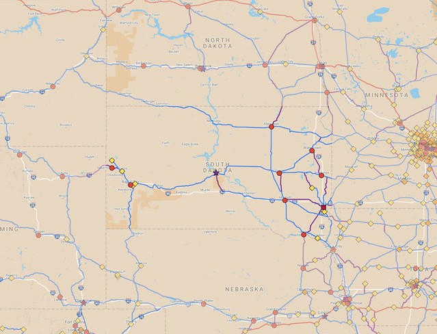
| A suggested system of routes to connect all cities larger than 5,000 people in South Dakota and into surrounding states (zoom in on South Dakota, or see other states here). |
South Dakota's population has grown by about 48% from 1970 to today, so the overall travel market is significantly bigger than it was when the last services disappeared from the state.
Above, I have a map of routes that I think would be good to look at reactivating with passenger service. All of the blue lines are existing freight routes, most of which had some form of passenger service in the past. The purple routes are mostly along former rail lines that have now been abandoned, but I invented a few routes that would be brand-new.
Unlike the cities in North Dakota, which are mostly laid out along two major east-west lines, the communities in South Dakota are much more scattered around, making it difficult to thread a single route through multiple cities. In mapping out possibilities, I've tried to stick to existing rail corridors as much as possible, followed by former routes, and adding routes of my own invention as a last resort. The scattered pattern of cities in South Dakota has made this one of the more challenging maps for me to put together.
Rather than relying on long-distance routes going all the way to Chicago, I feel it would be better for new services to focus on shorter routes, especially those that have relatively large cities within about 6-8 hours of travel time from Sioux Falls. A couple longer routes might also make sense.
High-priority corridors would include Sioux Falls to Omaha via Sioux City, Sioux Falls to the Twin Cities (a few routes available, my preference would be to go via Mankato), and Sioux Falls to Fargo (the best existing route is via Willmar, Minnesota, though it could be shortened somewhat by building some lines closer to the Interstate 29 corridor).
Rapid City in the western part of the state is South Dakota's second-largest city, and is a major gateway to the Black Hills region. This part of the state is closer to Denver than it is to the Twin Cities, so service heading south/southwest toward Colorado would be good to examine, as well as connections to Cheyenne, Wyoming, that state's capital and largest city. The rail line through Pierre and Rapid City comes to an end at Colony, Wyoming (not shown on the map), which makes it impossible to directly reach cities farther west. I suggest building a new line from around Whitewood, South Dakota to Moorcroft, Wyoming (a distance of about 80 miles), which would allow direct access from the Rapid City area into southern Montana.
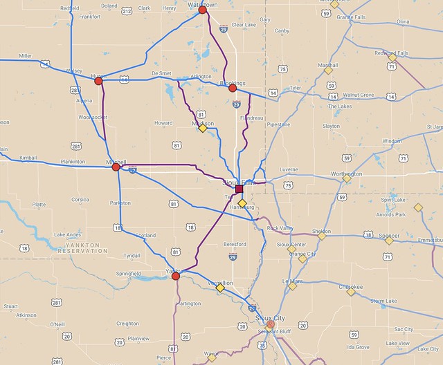
Within South Dakota, there's some potential for routes radiating outward from Sioux Falls to smaller cities, though they would have to be mostly rebuilt or built from scratch. Lines southwest from Sioux Falls to Yankton and west to Mitchell have been almost completely ripped up, and it appears that there has never been a line going all the way from Sioux Falls north to Brookings. Trains could get about 60% of the way by following existing and abandoned track, but the remaining part would need to be built new.
There's never been a direct line between Mitchell and Huron either. Instead, there's a route that runs somewhat west through the town of Wolsey. A more direct link would be better, though a bus or rail shuttle between Wolsey and Wolsey and Huron could be used as an interim solution. A former route between Brookings and Watertown that looks appealing has also been abandoned.
Out west, the story is somewhat better, since Rapid City directly connects to Sturgis and Belle Fourche. The nearby town of Spearfish is the largest city in South Dakota that lacks any sort of rail service. It could be connected by the potential new route between Whitewood, SD and Moorcroft, WY, that I suggested earlier.
 |
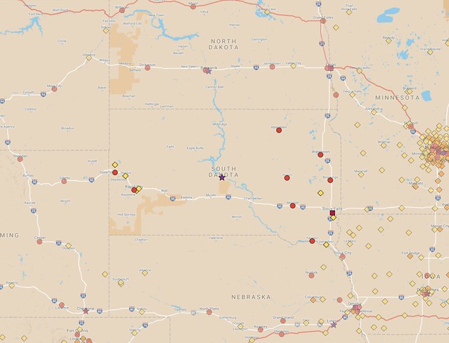
| The places larger than 5,000 people in South Dakota add up to about 51% of the state's population. |
Smack in the middle of South Dakota is the state capital, Pierre. It is the second-smallest state capital in the country by population, with around 14,000 residents. Only Montpelier, Vermont is smaller, though amazingly enough, Montpelier has Amtrak service. Of course, New England has many small towns, so Montpelier is far less isolated. Pierre is more than 115 miles from Huron, the nearest town of more than 5,000 people. It obviously doesn't have any Amtrak service today, though the city does rely on Essential Air Service subsidies to connect airline passengers to Denver.
The small populations of Pierre and Montpelier are one reason why I have used a threshold of 5,000 residents when making my rail maps. I think state capitals are places that are significant enough to warrant rail service, even if such service might not pencil out in standard benefit-cost analyses. That said, it makes sense to set up the best service possible. Since South Dakota's two largest cities are on opposite sides of the state, it would make sense to have a line running from Rapid City to Sioux Falls via Pierre.
However, as I mentioned above, there are relatively poor connections into Sioux Falls along east-west routes. The current line through Pierre is operated by the Rapid City, Pierre and Eastern Railroad (RCP&E), but the shortest path from Sioux Falls from Pierre by existing rails today is a strange zig-zag path to Wolsey, then running on BNSF Railway tracks south and east through Mitchell to the small town of Canton by the Iowa border before making a sharp 300°-plus turn back to enter the city via the suburb of Harrisburg.
At least one significant segment of rail would need to be built or rebuilt to make Sioux Falls directly accessible from the west or northwest. One interesting possibility is to use a line that roughly parallels Interstate 90, which is operated by the Dakota Southern Railway. The rail line is owned by the state, but operation of trains on the route is contracted out. There has never been a direct connection to Pierre from that line, but making one would leverage state-owned infrastructure.
However, using that line would require building new tracks both near Pierre and again between Mitchell and Sioux Falls (a little over 100 miles total), so a route from Pierre via the RCP&E is probably more practical. A former rail bed running 30 miles from Lake Preston (about halfway between Huron and Brookings) down to Madison is probably a better solution for connecting Pierre to South Dakota's largest city.
The line through Pierre could also be used as a through route for trains running from the Twin Cities to Denver. Notably, Denver is the second-most common destination for travelers flying out of MSP Airport, after Chicago. At about 1,000 miles, it could take 16 to 20 hours for a conventional train service to travel the distance, so a train may not draw many travelers going end-to-end, though it could be a good alternative for people only going 1/3 to 1/2 the distance. For instance, flying from Pierre to the Twin Cities is time-consuming today, taking at least 5 hours, since all travelers must go through Denver first.
Another interesting long-distance possibility is to restore passenger service along the former Milwaukee Road Olympian Hiawatha route through northern South Dakota, southwestern North Dakota, and into Montana. Unfortunately, this is a low-population route, but it would provide coverage through a little-served area and would be an alternative for anyone traveling from the Twin Cities into southern Montana, though that would be a fairly low priority, in my book.
If all of the lines I suggest in my map were to be put to use, about 1,525 miles of existing track would see passenger service reactivated, and another 375 miles would be built or rebuilt, for a system total of about 1,900 miles. However, my map includes some redundant or indirect routes that could be eliminated to shrink down the total.
Adding passenger rail service is a challenge everywhere in the U.S., and South Dakota has some of the biggest challenges due to being a low-population state that has been without passenger trains for nearly 50 years. Still, I think there's a strong case for at least linking Sioux Falls into the Amtrak system. With some effort, a good in-state rail system could be built, likely better than what had been available for state residents even at the height of rail travel in the country. A focus on short- to medium-distance travel would likely bring the greatest benefit, though it will also require a lot of cooperation surrounding states to fully exploit the possibilities that exist today.

