Thursday, May 30, 2024

Congestion point: Columbus, WI

The Amtrak station building in Columbus, Wisconsin. From Wikimedia user Downspec, CC-BY-SA

I had a nice little trip on Amtrak's Borealis this past Saturday, May 25th, which allowed me to visit Winona for a few hours. My trip down was smooth, though I got a bit frustrated by delays on the way back. It turns out that my trip to Winona was on the best-performing Borealis train trip so far, and the only one to arrive in Chicago with zero delay up til now. However, my trip back ended up arriving 40 minutes late. I'll take a look at what may be going on with the eastbound/southbound train no. 1340 in the future, but for now I'd like to take a look at one of the likely reasons why my return trip, the westbound/northbound train no. 1333, picked up so much delay.

I included this chart in my previous post welcoming the beginning of Borealis operation. It's a stringline diagram, showing the approximate scheduled location of each train on a particular corridor over time. What I'd like to focus on in this post is the first crossing point of the longer lines, which occurs near the "CBS" horizontal line representing Columbus station in Wisconsin.

That point in the graph shows where and when the eastbound Empire Builder, train no. 8, is intended to meet the westbound Borealis, train no. 1333. Train 8 is scheduled to depart St. Paul at 8:50 am, leave Columbus at 1:47 pm, and continue on to arrive in Chicago at 4:45 pm. Train 1333 is scheduled to depart Chicago at 11:05 am, leave Columbus at 1:41 pm, and reach St. Paul at 6:29 pm.

The difference of just 6 minutes between the schedule of these two trains will mean that they will often both want to be at Columbus station at the same time, or at least in very close proximity. If they're both running exactly on time, they should run headlong into each other just west of town.

The good news is that there is double-track in Columbus, which should allow the two trains to pass each other. Google Streetview even shows two platforms at the station, though they are in poor condition according to this imagery from 2021.

Google Streetview image of the Columbus station platforms and tracks, with a simple wire fence between them

However, looking through location history of trains that have run so far, the westbound Borealis is frequently getting stuck at a point east of Columbus, halfway between Astico and Reeseville, waiting for the Empire Builder or other trains to pass. This is one of the most obvious places causing delay for westbound trains, a slowdown which is proving hard for trains to recover from as they make their way to St. Paul.

Borealis trains are racking up significant delays between Milwaukee and Columbus

So, what's going on here?

Well, first off, I'm hoping this is just a temporary situation. Columbus is one of Amtrak's many stations that are undergoing construction to upgrade platforms, walkways, and other parts of the station area to current ADA standards. Work is expected to be completed in Amtrak's next fiscal year, meaning sometime after October 1st. While this won't provide high platforms like those present in many East Coast cities, they will be raised up several inches and will get yellow tactile pavers like what we're accustomed to at urban rail and enhanced bus stops.

Based on video from news outlets and YouTube channels such as Trains Are Awesome, where Thom visited Columbus for an afternoon, it looks like only one of the two platforms is currently able to be used.

Okay, so one track is out of commission for passenger service. That shouldn't be such a big deal, right? The trains can just cross over to the other track somewhere nearby, right?

Well, no, unfortunately.

The map above shows the area of double- and single-tracking near Columbus (zoom in to see the track hidden by the icons). Double-tracked sections are shown in an orange-yellow color, and single-tracked sections are shown in dark red. I've included green "X" icons showing where switches are located, and stoplight icons indicate ends of signal blocks, generally spaced about 2 miles apart. Columbus is in a long stretch of about 23 miles of double-tracking, but unfortunately, the nearest crossing between those tracks is about 6 miles east of the city, which is where the westbound Borealis is often getting stuck.

Critically, that crossover point is on the opposite side of town from where the Empire Builder and Borealis are scheduled to meet each other. West of the station, there aren't any real crossing points that can be used in this situation. The double-track section begins around 7 miles west of town, but that only provides the eastbound trains the option of going on the track with the out-of-service platform. Combined with the nearly 11-mile single-track stretch running from near Doylestown west to Wyocena, that effectively creates a 24-mile single-track section for passenger trains (from Wyocena through Columbus to the crossover between Astico and Reeseville).

That distance really closely corresponds to the delays the no. 1333 trains have been experiencing.  Pretty wild that a 400-foot stretch of missing pavement can have such an effect—get delayed by 15 minutes or so getting to Columbus as the track clears, only to arrive late to the congested east Twin Cities region, and get delayed even further due to missed windows.

Well, I'm taking a bit of a leap in assuming that's what's going on, but it seems to be the simplest explanation. I hope the station construction can be accelerated, at least enough to get both platforms usable.

I'm not sure how the train crews will the different groups of riders, especially since Columbus hasn't had a station attendant since 2017—it would probably make sense for this station to be staffed, just since someone should be around to shepherd people around to the right places before the trains show up. They're long enough to block the nearby crossings while boarding and disembarking happens, so it's really important for passengers to be in the right spots ahead of time. The station has had a simple fence between the tracks since 2016, so it appears that passengers have to walk down to Ludington Street just east of the station to cross over to the other side.

A more robust solution would be to add crossover tracks west of the station, to allow trains to switch tracks much closer to the stop and at a point that naturally aligns with the schedule. It would mean that only one platform would need to be used, and would also help reduce the chance that a late Empire Builder would induce even greater delays. There is a set of block signals about half a mile away from the station past Lewis Street that would probably be an ideal spot to add switches.

There are track improvements planned in La Crosse, La Crescent, and Winona that are supposed to help the Borealis and any future added service operate more smoothly. Perhaps that will shift the schedules a bit too. If those changes allow the Empire Builder to consistently arrive a several minutes earlier, that would shift the meeting point east of Columbus station and reduce the need for any track changes there.

Of course, a lot of this trouble would be eliminated if we could get a commitment to converting much more of the whole route to double-tracking. The single-track corridors that dominate rail in the U.S. definitely make it much harder to add new passenger service here vs. what's possible in Europe and elsewhere. That flexibility would be priceless.

Tuesday, May 28, 2024

Welcome to the Borealis

Amtrak Borealis train waiting to depart St. Paul Union Depot on May 25th (further description on the Flickr version)

Finally.

It has taken a lifetime, but there are two train pairs a day running again on tracks between St. Paul and Chicago. Amtrak's new Borealis joins the storied Empire Builder to expand upon the extremely skeletal passenger service we've had to deal with across the Midwest and the rest of the country. Amtrak operated overnight sleeper trains from 1972 to 1981 (the Empire Builder complemented by the North Coast Hiawatha / Twin Cities Hiawatha and later North Star), but you'd have to run farther back to the pre-Amtrak era before 1971 to have multiple daytime trains on the route.

It's turned out to be a bittersweet time for me, since my father had moved into a senior care facility in the weeks leading up to the start of service. One of the reasons I started this blog in 2010 was because that marked nearly 20 years since my dad brought my brother and me to a public meeting about high-speed rail service being planned between the Twin Cities and Chicago, and we went to an event in Rochester where people were hoping it could pass through that city. Now, we're approaching 35 years since that study was done, and prospects of real HSR or even reasonably-frequent standard service seem more distant than ever—especially anything connecting Rochester.

Still, it has been a huge morale boost to see this train start running, much like how the start of Northstar commuter service in 2009 altered the way I looked at rail connectivity. That was a big contributor to why I started digging more into regional and intercity rail, while my previous focus had been more on metro-area streetcar and current/future light rail lines. I think a lot of people tend to focus too much on particular modes, while we need a holistic approach that provides mass transportation that works at many different scales, ranging from local ones that have stops just a few blocks apart up to high-speed lines with stops dozens or even hundreds of miles apart.

I have many thoughts swirling about how the Borealis is currently operating, what needs to be done to ensure its success, and options for future expansion. I hope this is a turning point for rail service in our region, and I'm glad to see there are other bright spots across the country where improvements are underway. Perhaps best of all, we finally have federal coordination through the Corridor ID (Identification and Development) program, which looks like it will be able to shepherd along the many different state and regional plans that often suffer from breakdowns in inter-state coordination. (It's a shame that states have had to put so much direct support into planning and funding anything under 750 miles in length—routes almost guaranteed to be interstate in nature, and always putting such lines at risk when states get out of sync with each other in terms of policy and planning.)

For now, I just want to welcome the Borealis, and hope to ride it often. I've already been able to take a day-trip down to Winona and back, and in combination with the Empire Builder, it will make it much easier to get to points further south and east. I have a future trip scheduled to La Crosse that will use a combination of trains, and we'll just have to see where else I decide to go.

A stringline chart showing the current schedules of the Empire Builder, Borealis, and Hiawatha trains between St. Paul, Milwaukee, and Chicago

Thursday, December 8, 2022

Another try at passenger service to Madison

Map of potential station locations in Madison, with six segments of track highlighted.
The Wisconsin State Journal reports on another study for linking Madison with Amtrak, with a selection process beginning that is examining six possible station locations. This of course comes a dozen years after the old high(er)-speed rail plan for connecting Madison to Milwaukee and Chicago was killed off at the end of Jim Doyle's term as governor, just prior to Scott Walker taking office following the 2010 elections.

Four of the six options are on the east side of the city, which are likely the most practical since they could potentially allow through-running on existing tracks to the Twin Cities that would still mostly follow the existing Amtrak Empire Builder route. Running through on the Madison isthmus would require either continuing west along the Wisconsin River corridor to Prairie du Chien (south of Amtrak's current routing) and north along the Mississippi, or building a connection west of Madison to turn north and rejoin the Canadian Pacific tracks Amtrak uses.

This appears to be a study being led by the City of Madison rather than WisDOT, and it doesn't seem to be tied to any actual plans for new train service. Instead, this looks like it's just to ensure the city has good plans in place if and when a rail service initiative actually happens, such as one using funding from the recent federal infrastructure bill. (Map from the city's site.)

Monday, November 21, 2022

Video tour of the Autumn Colors Express

Mike on the DownieLive YouTube channel got a ride on a deadhead of the railcars used in the 2022 Autumn Colors Express, including the Milwaukee 261 / Railroading Heritage of Midwest America group's Super Dome and the Cedar Rapids skytop lounge car. He got a trip from Chicago out to Huntington, West Virginia. The video includes clips from cars throughout the train, from historic 20th Century Limited cars near the locomotive end to the 261 group's cars at the tail end.

I think this is the first video I've actually watched from this channel, but I've seen others from it recommended to me, including one on the Rocky Mountaineer in Canada.

Friday, October 28, 2022

Twitter break

Since this site is linked from my bio on Twitter, I'll mention that I'm taking some time off from it. The election had already been making me have to keep it at arm's length, and the acquisition worries the hell out of me. For the moment, I'm planning to be off for about two weeks.

It's been the best place to get breaking news, but has always been a firehose, too. It's easy to spend 3-4 hours there per day, but it also keeps my brain in a jumble all the time with the randomness of what I see. I'm not sure if I'll return to blogging, but getting away from Twitter for a while would help me get back to longer-form thinking, rather than trying to fit things into 280 characters.

I hate to have to explicitly say it, but I hope anyone reading this will be voting for Democrats or the most progressive candidates that they can during this election cycle. The aim of this site had originally been to look forward to a renewed future of rail travel from funding put forth in 2008-2009, but unfortunately the Republican backlash of 2010 stopped a great deal of that forward momentum from happening, and it took me years to realize how much things had gotten stymied.

Building an effective and efficient transportation system requires looking past color boundaries and political differences to work to serve everyone. I do not wish to punish people who vote differently than me or who have a different background, but it's clear there are far too many people largely congregating on the Republican side who do feel that way. That has to be stopped, or only tragedy will ensue.

As for a possibly post-Twitter world, I'm not sure where I may end up. I'd like to post here again, and I hope to return to being more active on Flickr. The local UrbanMSP forum and Streets.mn blog may get more traffic from me too. I also have some long-lingering electronics projects I'd like to get back to, such as ever-present ideas for cheap real-time transit departure displays. And I need to do something that lets me see people in the real world, as we live with the effects of the pandemic that caused so much isolation.

Reverse and remove spaces for mail: m o c . l i a m g @ 6 d a l u m

Thursday, March 1, 2018

Returning to the rails in South Dakota

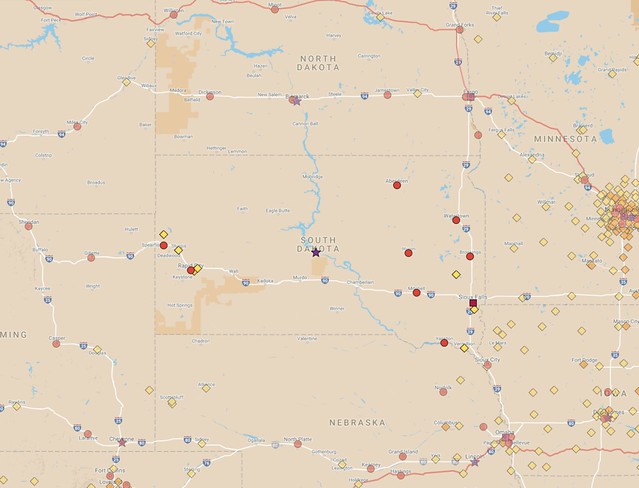
sd-existing-cities-2017-01-06 by Michael Hicks, on Flickr
South Dakota is the only state among the lower 48 that has never had Amtrak service. The last regularly-operated passenger trains ran left the state in 1969.
Following an extended hiatus to surf the torrent of government news these days, I'm back with another set of maps to explain the current situation with passenger rail in the U.S. and a possible vision for the future. This time, I'm focusing on our neighbor to the southwest, South Dakota. For my previous posts on this topic, as well as some in-progress maps for other states, see this list. Below, I'll talk about former service in the state and several suggestions on what I feel are the best opportunities to bring it back.

The current status for passenger rail in South Dakota is simple to convey: There isn't any. There is at least one heritage railroad operation (the Black Hills Central Railroad is most well-known), but there aren't any true intercity train routes, making South Dakota unique among the states. The nearest Amtrak routes are the Empire Builder running to the north through Montana, North Dakota, and Minnesota, and the California Zephyr running to the south through Colorado, Nebraska, and Iowa.

South Dakota is the only state among the lower 48 that has never had Amtrak service. The last passenger route ended operation in 1969, two years before Amtrak took over the most of the remaining passenger routes in the country. Wyoming, South Dakota's neighbor to the west, is the only other state among the lower 48 to lack passenger trains today, though it did have them for several years in the Amtrak era when the San Francisco Zephyr ran through the state. Even Alaska has passenger service through the Alaska Railroad.

Like other parts of the country, South Dakota's rail system peaked in the early 20th century. About 4,420 miles of railroad have been constructed in the state through its history, but most of that has been abandoned. The state still had 1,753 miles of railroad as of 2012, a little over half as much as North Dakota, and about 39% of the rail mileage of Minnesota.

Map of South Dakota's rail system as of 2014 (source)
Sioux Falls is South Dakota's largest city, but unlike other states which tend to have many routes radiating from the most-populated places, there are relatively few ways to get directly in and out of the city today. The most significant existing east-west rail routes pass to the north or south, and even in the past, significant long-distance routes into and through the state bypassed Sioux Falls.

For instance, the Chicago and North Western Railway ran passenger service from Chicago as far west as Rapid City, near the Black Hills, but their route went north of Sioux Falls, through Brookings, Huron, and Pierre. That route had passenger service into South Dakota until 1960, when it was cut back to Mankato, Minnesota, and then it ceased passenger operation entirely in 1964.

One of the last lines to serve the state ran even farther north. It was a shortened route on the former Milwaukee Road transcontinental service to the Pacific Northwest, the Olympian Hiawatha. That train, which once ran from Chicago to Seattle/Tacoma, was cut back to Deer Lodge, Montana in 1961, then cut back again to Aberdeen, SD in 1964 (the largest city on the route between the Twin Cities and Billings, Montana).

With such a small endpoint, that service only lasted another 5 years. Passenger service exited South Dakota entirely in April 1969. There was also a Chicago, Burlington and Quincy Railroad line that operated through the extreme southwest corner of the state via Edgemont, and it ended passenger service through the state a few months later in August.

It appears that the last train to serve Sioux Falls was a branch of the Milwaukee Road's Arrow service that primarily ran from Chicago to Omaha, Nebraska. The line branched off in the small town of Manilla, Iowa. It dropped service to Sioux Falls in 1965, then was discontinued entirely two years later.

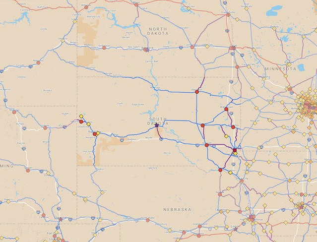
sd-full-cities-2017-01-08 by Michael Hicks, on Flickr
A suggested system of routes to connect all cities larger than 5,000 people in South Dakota and into surrounding states (zoom in on South Dakota, or see other states here).
It's a bit strange to me that South Dakota was stuck with this fate. I think it has a lot to do with a Chicago-centric focus by the freight railroads, neglecting the need for more local travel. According to a 1957 timetable, it took 17 hours and 25 minutes to take the Arrow from Chicago to Sioux Falls, on a line that skipped past both Des Moines and Omaha and went through much smaller communities instead.

South Dakota's population has grown by about 48% from 1970 to today, so the overall travel market is significantly bigger than it was when the last services disappeared from the state.

Above, I have a map of routes that I think would be good to look at reactivating with passenger service. All of the blue lines are existing freight routes, most of which had some form of passenger service in the past. The purple routes are mostly along former rail lines that have now been abandoned, but I invented a few routes that would be brand-new.

Unlike the cities in North Dakota, which are mostly laid out along two major east-west lines, the communities in South Dakota are much more scattered around, making it difficult to thread a single route through multiple cities. In mapping out possibilities, I've tried to stick to existing rail corridors as much as possible, followed by former routes, and adding routes of my own invention as a last resort. The scattered pattern of cities in South Dakota has made this one of the more challenging maps for me to put together.

Rather than relying on long-distance routes going all the way to Chicago, I feel it would be better for new services to focus on shorter routes, especially those that have relatively large cities within about 6-8 hours of travel time from Sioux Falls. A couple longer routes might also make sense.

High-priority corridors would include Sioux Falls to Omaha via Sioux City, Sioux Falls to the Twin Cities (a few routes available, my preference would be to go via Mankato), and Sioux Falls to Fargo (the best existing route is via Willmar, Minnesota, though it could be shortened somewhat by building some lines closer to the Interstate 29 corridor).

Rapid City in the western part of the state is South Dakota's second-largest city, and is a major gateway to the Black Hills region. This part of the state is closer to Denver than it is to the Twin Cities, so service heading south/southwest toward Colorado would be good to examine, as well as connections to Cheyenne, Wyoming, that state's capital and largest city. The rail line through Pierre and Rapid City comes to an end at Colony, Wyoming (not shown on the map), which makes it impossible to directly reach cities farther west. I suggest building a new line from around Whitewood, South Dakota to Moorcroft, Wyoming (a distance of about 80 miles), which would allow direct access from the Rapid City area into southern Montana.

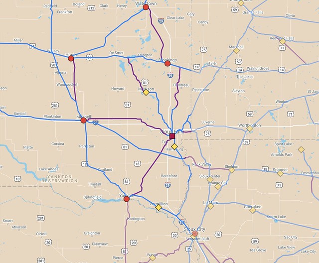
sd-railmap-sioux-falls-2018-02-25 by Michael Hicks, on Flickr
Close-up of suggested routes around Sioux Falls, including parts of South Dakota, Minnesota, Iowa, and Nebraska. Unfortunately, direct routes to many of the nearest significant cities have seen major abandonments.

Within South Dakota, there's some potential for routes radiating outward from Sioux Falls to smaller cities, though they would have to be mostly rebuilt or built from scratch. Lines southwest from Sioux Falls to Yankton and west to Mitchell have been almost completely ripped up, and it appears that there has never been a line going all the way from Sioux Falls north to Brookings. Trains could get about 60% of the way by following existing and abandoned track, but the remaining part would need to be built new.

There's never been a direct line between Mitchell and Huron either. Instead, there's a route that runs somewhat west through the town of Wolsey. A more direct link would be better, though a bus or rail shuttle between Wolsey and Wolsey and Huron could be used as an interim solution. A former route between Brookings and Watertown that looks appealing has also been abandoned.

Out west, the story is somewhat better, since Rapid City directly connects to Sturgis and Belle Fourche. The nearby town of Spearfish is the largest city in South Dakota that lacks any sort of rail service. It could be connected by the potential new route between Whitewood, SD and Moorcroft, WY, that I suggested earlier.

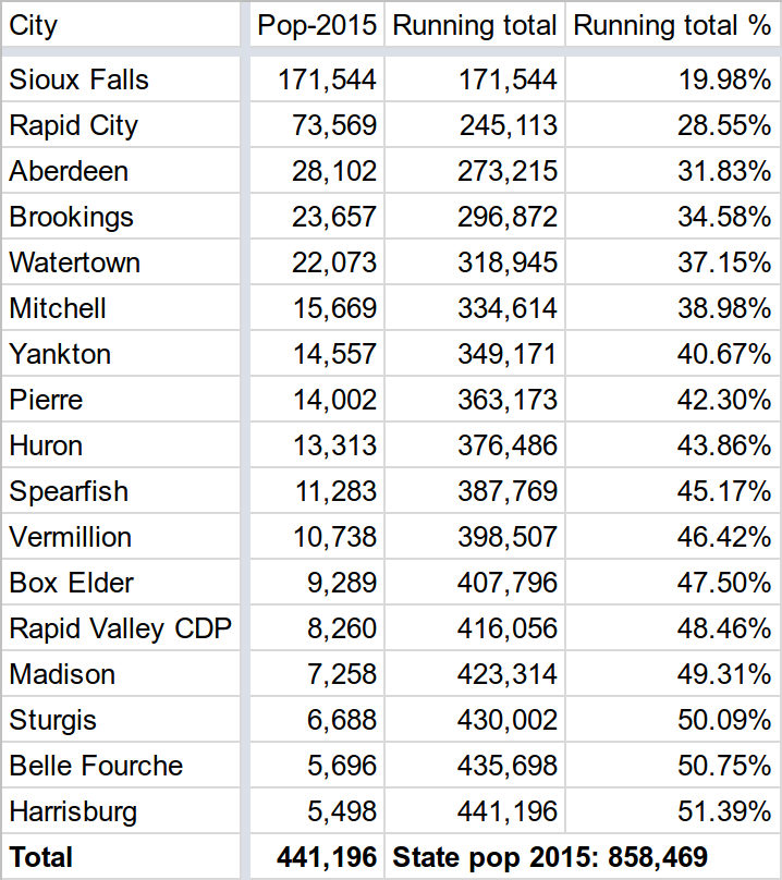
The places larger than 5,000 people in South Dakota add up to about 51% of the state's population.

Smack in the middle of South Dakota is the state capital, Pierre. It is the second-smallest state capital in the country by population, with around 14,000 residents. Only Montpelier, Vermont is smaller, though amazingly enough, Montpelier has Amtrak service. Of course, New England has many small towns, so Montpelier is far less isolated. Pierre is more than 115 miles from Huron, the nearest town of more than 5,000 people. It obviously doesn't have any Amtrak service today, though the city does rely on Essential Air Service subsidies to connect airline passengers to Denver.

The small populations of Pierre and Montpelier are one reason why I have used a threshold of 5,000 residents when making my rail maps. I think state capitals are places that are significant enough to warrant rail service, even if such service might not pencil out in standard benefit-cost analyses. That said, it makes sense to set up the best service possible. Since South Dakota's two largest cities are on opposite sides of the state, it would make sense to have a line running from Rapid City to Sioux Falls via Pierre.

However, as I mentioned above, there are relatively poor connections into Sioux Falls along east-west routes. The current line through Pierre is operated by the Rapid City, Pierre and Eastern Railroad (RCP&E), but the shortest path from Sioux Falls from Pierre by existing rails today is a strange zig-zag path to Wolsey, then running on BNSF Railway tracks south and east through Mitchell to the small town of Canton by the Iowa border before making a sharp 300°-plus turn back to enter the city via the suburb of Harrisburg.

At least one significant segment of rail would need to be built or rebuilt to make Sioux Falls directly accessible from the west or northwest. One interesting possibility is to use a line that roughly parallels Interstate 90, which is operated by the Dakota Southern Railway. The rail line is owned by the state, but operation of trains on the route is contracted out. There has never been a direct connection to Pierre from that line, but making one would leverage state-owned infrastructure.

However, using that line would require building new tracks both near Pierre and again between Mitchell and Sioux Falls (a little over 100 miles total), so a route from Pierre via the RCP&E is probably more practical. A former rail bed running 30 miles from Lake Preston (about halfway between Huron and Brookings) down to Madison is probably a better solution for connecting Pierre to South Dakota's largest city.

The line through Pierre could also be used as a through route for trains running from the Twin Cities to Denver. Notably, Denver is the second-most common destination for travelers flying out of MSP Airport, after Chicago. At about 1,000 miles, it could take 16 to 20 hours for a conventional train service to travel the distance, so a train may not draw many travelers going end-to-end, though it could be a good alternative for people only going 1/3 to 1/2 the distance. For instance, flying from Pierre to the Twin Cities is time-consuming today, taking at least 5 hours, since all travelers must go through Denver first.

Another interesting long-distance possibility is to restore passenger service along the former Milwaukee Road Olympian Hiawatha route through northern South Dakota, southwestern North Dakota, and into Montana. Unfortunately, this is a low-population route, but it would provide coverage through a little-served area and would be an alternative for anyone traveling from the Twin Cities into southern Montana, though that would be a fairly low priority, in my book.

If all of the lines I suggest in my map were to be put to use, about 1,525 miles of existing track would see passenger service reactivated, and another 375 miles would be built or rebuilt, for a system total of about 1,900 miles. However, my map includes some redundant or indirect routes that could be eliminated to shrink down the total.

Adding passenger rail service is a challenge everywhere in the U.S., and South Dakota has some of the biggest challenges due to being a low-population state that has been without passenger trains for nearly 50 years. Still, I think there's a strong case for at least linking Sioux Falls into the Amtrak system. With some effort, a good in-state rail system could be built, likely better than what had been available for state residents even at the height of rail travel in the country. A focus on short- to medium-distance travel would likely bring the greatest benefit, though it will also require a lot of cooperation surrounding states to fully exploit the possibilities that exist today.

Monday, May 8, 2017

The stagnant investment in Amtrak, by station count


Amtrak, the country's intercity passenger rail company, has had its funding stuck in the doldrums ever since it was founded in 1971. There have been sporadic bursts of money to the government-sponsored company, mostly to invest in new locomotives and train cars and the occasional upgrade to the tracks on particular routes. However, there hasn't been a sustained effort to repair and expand underlying infrastructure on a system-wide basis. This is reflected in the fact that the number of stations served by Amtrak has barely changed over time, in stark contrast to the growth in urban rail systems over the same period.

The graph above shows the number of stations for both Amtrak and the nation's urban rail systems from 1984 to 2014. Over the course of 30 years, urban transit systems grew from 1,822 stations to 3,355, an increase of 84%. Growth in urban systems been pretty linear, with about 51 stations added per year on average.


Meanwhile, Amtrak began the period with 510 stations and ended with just 518, an aggregate increase of just 1.6%. Amtrak's station count has fluctuated more than that over time, with the system reaching a low of 487 stations in 1987 and attaining a peak of 542 stations in 1996. It's a bit difficult to explain why Amtrak has been stuck in this rut for so many years while there has been a sustained investment in local rail service within metropolitan areas, but there has been a lack of coordination for new or restored routes in most of the country.

The United States' population grew from 238.5 million to 318.9 million over that period of time, so Amtrak's reach should have enlarged too. If Amtrak had grown at the same rate as our urban transit systems, there would have been about 940 stations in their system as of 2014. That doesn't necessarily mean the system would have 84% more mileage, though: One of Amtrak's biggest failings is that most routes only have one train per direction per day. Increasing service frequency could allow a mix of local all-stop trains and faster limited-stop trains along a single route, with the local trains potentially serving new/restored infill stations along the way. (Many Amtrak trains today are essentially "hybrids" of what used to exist, stopping more frequently than old express services, but less often than what locals used to do.)

Each new or enhanced route requires the involvement of multiple cities and metropolitan areas, so it needs to at least be coordinated at a state level, and many good potential routes (even if they're fairly short) are spread across two or more states. Amtrak is structured so that individual states are responsible for planning and finding funding for routes that are less than about 700 miles (following legislative changes passed in 2008, the states can still get federal funding for building lines, but operational costs must be borne by the states for these shorter "corridor" routes). That creates a disincentive for the company to pursue new routes on its own, since adding even a single new train on a 700+ mile route is very expensive (hundreds of millions of dollars if the PRIIA studies from 2009 are any guide).

What's the right way to coordinate new intercity train lines in the country? The American Association of State Highway and Transportation Officials (AASHTO) played a critical role in organizing planning across states when the highway system was developed (back before "and Transportation" was added to the group's name), but it's not clear if they've ever had much of a hand in planning rail service. Their Standing Committee on Rail Transportation meets once a year for what they describe as a "debrief and networking meeting", which sounds like a very passive group (plus, the committee only has members from 33 states versus the 46 that are currently served by Amtrak). AASHTO should take their interstate coordinating role seriously and reexamine the potential for intercity rail across the U.S.

Here in Minnesota, we've also had a very weak structure for coordinating intercity rail plans. The state's Passenger Rail Office has been underfunded and understaffed, requiring a heavy reliance on outside consultants rather than MnDOT employees tasked with working in the best interest of the state. The Republican-held state legislature is attempting to entirely defund the office as part of the state budget, even though it has only represented a tiny percentage of MnDOT expenditures over its existence (a couple million dollars per year), and it's particularly galling to have it happen when the state is projected to have a $1.65 billion surplus anyway.

The employees of the Passenger Rail Office also have an essential role in helping lead monthly meetings of the Intercity Passenger Rail Transportation Forum, composed of stakeholders along the routes that are supposed to see passenger service added under the state rail plan. Defunding the Passenger Rail Office would probably stall out plans for future lines within the state, and we're far behind where we should be on implementing that plan.

Intercity trains don't get the same attention that urban rail systems do, and I find that to be a shame, since I think it makes it a lot harder for many people to give up their cars, even in cities with good transit service. I personally hold on to my car due to my need to travel to areas in or near Fargo, Eau Claire, and Rochester for family and work, and all of those places would get rail service if we implemented the plan that's been on the books since 2010.