Thursday, November 24, 2011

November 28, 2011 weekly rail news

Fun stuff:


Planning, funding, and construction news:

  • Central Corridor light-rail construction on the western stretch of University Avenue is said to be finished (at least in terms of laying track and reconstructing the road surface) and ready to fully reopen to car traffic. I haven't had a chance to see it for myself yet, though.

  • Work on the Saint Paul Union Depot's headhouse has progressed enough to allow Christos, the Greek restaurant in the lobby, to reopen on Thursday, December 1st.

  • Rather shaky but informative video of a walkthrough of the headhouse work, starting downstairs in the new carriageway area:


  • In southern Minnesota, a spur to Hartland has been abandoned and is expected to become a bike trail.

  • $928 million has been pledged to California from the U.S. DOT in order to build their first high-speed rail line.

  • The state of Michigan has received $150 million from U.S. DOT in order to acquire the rail line to Detroit. This action should pave the way for repairs and upgrades to the track to allow 110-mph service.

  • President Obama signed legislation that should allow federal dollars to be matched against the unique private funding for the planned M-1 light-rail line in Detroit.

Incidents

  • Service along MTA Metro-North Railroad's Port Jervis line has resumed in New York. It was severely damaged in Hurricane Irene. Despite resumption of service, repairs are expected to continue until June 2012.

Other:

A mile away from Bailey Elementary, a possible solution


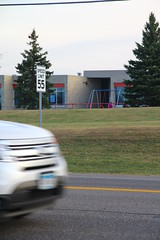
The roundabout at Bailey Road and Radio Drive in Woodbury.

When I first came across this image of a roundabout with dedicated tunnels for bikes and pedestrians, I thought I had somehow wandered onto David Hembrow's blog about cycling in the Netherlands, but no, it turns out this is an image of an American roundabout.  A Minnesotan roundabout. A Woodburian roundabout.

A roundabout in Woodbury?  With two lanes, bike paths, and tunnels?  Yep.

A few weeks ago, Mike Spack linked to an online presentation by Joe Gustafson of Washington County Public Works that covered the project.  It's the first fully two-lane roundabout in the state, so the county used it to experiment a bit and collected extra data about its performance—hence the reason for the presentation.

However, the main thing that jumped at me was the roundabout's location: It's at the intersection of Radio Drive and Bailey Road.  You might remember Bailey Road from news stories earlier this year about Gordon Bailey Elementary School.  It became a cause célèbre for Minnesota urbanists after it was reported that of the 620 students, none of them walked or rode bicycles to school.

img_5053
A 55-mph speed limit at an elementary school?
Now, I don't want to sound like a ratchety old fart talking about walking in eight-foot snowdrifts uphill both ways, but I did grow up in the southeastern Minnesota town of Byron, where kids within the city limits were (at the time) required to make their own way to and from school—whether it was by walking, biking, or getting a ride from a family member.  I mostly walked, but did ride my bike or get rides on occasion.  One of the main roads to my elementary school had a speed limit of 15 miles per hour, while others were normally 30 but restricted to 20 mph when students were present.

Because I grew up with a school on a slow street, I'm always amazed to see schools such as Bailey placed next to 55-mph suburban arterials.  Unfortunately, it has been a common practice in the United States for the past few decades.

Roads such as this can be deadly for students.  For me, this reality  came into stark relief when I was in high school—a student in nearby Kasson was killed crossing the 40-mph Mantorville Avenue (Minnesota State Highway 57) near that city's high school. He was hit fast enough to be lifted out of his shoes—the mental image of empty sneakers marking a crash victim's last footsteps is something that always sticks with me.

img_5024
Gordon Bailey Elementary's main entrance to the west side parking lot.

Due to my own experiences, I'm inclined to think that parents and kids feel unsafe crossing Bailey Road, and that's why every student gets driven or bused to school.  In the original reporting on the subject, parents gave a variety of reasons for driving their children, but the school's location still sticks out like a sore thumb.

So, how do you make this road—out on the edge of the urban boundary—feel safe?  Ideally, I'd like to see schools located in town centers, like the elementary I grew up with.  Built up near the edge of streets that are designed to be slow, even if the slow area only lasts a block or so.

img_5032
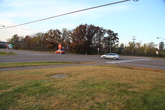
The school's closest intersection, a 4-way stop at Bailey Road and Woodlane Drive.
But here, we're dealing with an established facility that's on roads that are made for high speed.  Reducing the speed limit might help, but a road lined on one side by farmland is unlikely to be driven slowly.  Wide open spaces encourage wide open throttles, so a reduced speed limit would likely be ignored.

In this case, it seems the best option is to completely separate pedestrian traffic from the road, allowing people to get from one side to the other without having to wait for cars to pass or stop.

Tunnels or bridges across the road are the way to accomplish that.  Expensive solutions, but worth the money because they will save lives.  Certainly criticism would follow any such proposals, but critics should also recognize that they are usually remedies to problems that never should have existed in the first place.  Unwalkable locations bring latent costs with them, and building special grade-separated walkways just makes those hidden costs visible.

Schools should be built in walkable places, period.  They are engines of community, and should be treated as such.

Tuesday, November 22, 2011

Log of the Hiawatha, February 2, 1939

Here's a speed/timing log of a run of the Milwaukee Road's Hiawatha in early 1939. The Hudson F-7 locomotive must have been brand-new at the time. I'd like to find a log of a Morning Hiawatha run from 1940 or 1941, since they apparently went a bit faster following track upgrades (the Milwaukee worked on their construction methods and eventually set up 1-degree curves with 3½ inches of superelevation and ran trains over them at 100 mph). This appears to be an afternoon trip, and was scheduled to take 6h30 from Chicago to St. Paul. I believe the fastest schedule ever made for that portion of the trip was 6h15.

Oh, before I get to the main thing, here's a summary of the segments people may be interested in:

Scheduled trip time

ChicagoMilwaukeeSt. PaulMinneapolis
Chicago1:156:307:00
Milwaukee
5:155:45
St. Paul

0:30
Minneapolis


Recorded trip time

ChicagoMilwaukeeSt. PaulMinneapolis
Chicago1:12:456:31:406:57:02
Milwaukee
5:18:555:44:17
St. Paul

0:25:22
Minneapolis


The only stations served by the train were Chicago, Milwaukee, Portage, New Lisbon, La Crosse, Winona, Red Wing, St. Paul (Union Depot), and Minneapolis—a total of 9. An extra brief stop occurred when the train encountered a red signal, apparently due to a broken piece of track. The temperature in Minneapolis was "several degrees below zero [Fahrenheit]" upon arrival.

In contrast, the Empire Builder's stations are Chicago, Glenview, Milwaukee, Columbus, Portage, Wisconsin Dells, Tomah, La Crosse, Winona, Red Wing, and St. Paul (Midway)—a total of 11.  Midway station is located at roughly the same distance from Chicago as Merriam Park.

Nine streamlined cars, approximately 430 tons; Hudson-type (F-7) engine No. 100, tractive effort 50,300 lbs., 84-inch drivers, 23½ x 30-inch cylinders, boiler pressure 300 lbs. Engineer W. E. Stephens, Chicago-Milwaukee; Engineer H. B. Knowlton, Milwaukee-La Crosse; Engineer A. C. Hoard, La Crosse-Minneapolis.

Miles
StationsSpeedsTimeSchedule
0.0Lv.Chicago
1:00:00 p.m.1:00 p.m.
2.9PassWestern Avenue301:08:09
5.4
Pacific Junction521:11:581:09
6.4
Healy521:12:58
8.2
Grayland521:15:10
9.0
Mayfair491:16:19
10.2
Forest Glen671:17:41
11.6
Edgebrook731:19:00
14.3
Morton Grove851:21:08
16.2
Golf871:22:19
17.4
Glenview901:23:09
20.2
Techny921:25:07
20.3
Tower A-20921:25:121:22
20.9
Northbrook93, 90 curve1:25:37
23.9
Deerfield901:27:34
28.0
West Lake Forest96, 98, 82 curve1:30:03
32.3
Rondout801:32:511:30
36.8
Wilson921:36:08
38.6
Gurnee100, 90 curve1:37:15
42.9
Wadsworth93, 86 upgrade1:39:521:37
47.0
Russell86, 80 curve1:42:44
51.6
Ranney801:46:001:43
52.6
Truesdell841:46:44
57.5
Somers941:50:00
61.8
Sturtevant891:52:471:50
66.0
Franksville931:55:31
68.1
Tower A-68931:56:541:54
69.4
Caledonia95, 1001:57:41
72.8
Oakwood97, 981:59:46
77.9
Lake95, 100, 71 curve2:02:572:00
80.3
Powerton71, 60 curve, 402:04:46
83.9
Washington Street312:08:522:09
85.0Ar.Milwaukee
2:12:452:15

Lv.Milwaukee
2:19:182:17
87.0PassMilwaukee Shops39, 442:23:33
88.2
Grand Avenue34, 47, 442:25:19
90.4
Wauwatosa472:28:27
94.9
Elm Grove68, 70, 59 curve2:33:13
99.2
Brookfield75, 842:37:152:34
101.9
Duplainville802:39:11
105.3
Pewaukee91, 68 curve2:41:41
109.9
Hartland70, 822:44:582:43
112.6
Nashotah762:47:05
114.8
Okauchee872:48:40
117.8
Oconomowoc90, 86, 902:50:392:48
123.5
Ixonia88, 952:54:31
131.0
Watertown333:00:102:58
135.3
Richwood81, 88, 77 curve, 8[?]3:04:51
140.6
Reeseville713:08:49
145.9
Astico90, 923:12:44
149.7
Columbus913:15:15
153.3
Fall River86, 70 curve3:24:073:24
159.1
Doylestown853:22:15
162.5
East Rio91, 70 curve3:24:073:24
163.9
Rio76, 67 curve3:25:37
168.9
Wyocena90, 923:29:36
176.7
Portage Junction503:35:10
177.9Ar.Portage
3:37:243:38

Lv.Portage
3:41:043:41
186.7PassLewiston903:49:53
188.5
Cheney92, 70 curve3:51:05
194.8
Wisconsin Dells653:55:50
203.4
Lyndon99, 100, 89, 984:02:22
214.0
Mauston88, 894:09:06
221.0Ar.New Lisbon
4:15:20

Lv.New Lisbon844:17:404:18
227.0PassCamp Douglas59, 914:24:10
233.3
Oakdale90, 93, 91, 934:29:00
239.8
Tomah88, 31 switches4:33:18
243.2
Tunnel City34, 45 tunnel4:36:244:36
245.9
Raymore74, 934:39:44
251.4
Camp McCoy91, 954:44:00
256.2
Sparta88, 904:46:414:46
262.8
Rockland904:51:13
266.4
Bangor90 until slowing4:53:55
271.0
West Salem80, 904:56:49
278.0
Medary47, 575:02:155:04
279.6
Grand Crossing405:04:08
280.8Ar.La Crosse
5:07:355:09

Lv.La Crosse475:14:285:14
281.2PassWest Wye Switch25, 485:16:15
282.8
Bridge Switch39, 535:18:58
284.1
River Junction36, 705:20:42
288.2
Dresbach725:24:46
289.9
Dakota715:26:16
293.7
Donehower735:29:31
298.5
Lamoille74, 715:33:31
303.1
Homer745:37:19
305.4
CGW Crossing605:39:28
307.5Ar.Winona
5:42:36

Lv.Winona
5:44:285:45
309.4PassTower CK455:48:35
313.6
Minnesota City67, 695:52:47
323.7
Minneiska716:01:38
326.9
Weaver71, 806:04:22
334.4
Kellogg71, 80, 706:10:24
340.5
Wabasha626:15:33
342.4
Reads Landing69, 706:17:19
353.0
Lake City69, 80, 706:26:42
359.3
Frontenac77, 82, 60 curve, 736:31:51
369.9Ar.Red Wing
6:41:40

Lv.Red Wing
6:42:406:43
372.0PassIsland Siding716:45:45

Ar.Red Signal Indication
6:51:30

Lv.Red Signal Indication
6:51:55

Rearof train over broken rail89, 806:55:20
384.5PassBlackbird Junction857:02:40
390.3
Hastings40, 35 bridge7:06:586:59
391.5
St. Croix Tower31, 60, 807:08:43
403.4
Newport59, 807:20:207:15
407.9
Oakland607:24:12
408.9
St. Paul Yard70, 50 until Xing7:25:16
411.5Ar.St. Paul
7:31:407:30

Lv.St. Paul
7:34:007:33
412.4PassChestnut Street307:37:157:35
413.3
Fordson Junction38, 45, 487:38:537:37
417.3
Merriam Park487:45:007:44
418.7
Tower G50, 227:47:187:47
420.5
South Minneapolis277:50:267:50
422.4Ar.Minneapolis
7:57:028:00
NOTE: Speeds as shown represent speed at station, occasionally on slow order curves, and maximum and minimum between stations.

Sunday, November 20, 2011

November 20, 2011 weekly rail news

The big story:


View Twin Cities to Chicago 110-mph rail in a larger map


We have our route. Yes, it's the former route of the Hiawatha, now plied by Amtrak's Empire Builder. It's the route you know and love, so there may not be any new destinations to visit—but you should actually be able to plan a day- or weekend trip and be ensured of getting there and back on time. For the leisurely traveler, there won't be any more need to get up at 6 AM to catch the train (just in case the Builder is running on time). And with six daily round-trips planned for the new service, there shouldn't be any more need to plan an extra day in Chicago for a connecting train (just in case the Builder is running six hours late).

The price tag for this endeavor is estimated at $2.4 billion (in 2010 dollars), with costs split almost exactly down the middle between Minnesota and Wisconsin—$1.2 billion each (a price that seems to resemble the cost for a certain sports franchise's planned stadium).

Price appears to be the primary reason this route was chosen: It's a few hundred million dollars cheaper than the next-least-expensive option. The current route doesn't have any grades greater than 1%, and centralized traffic control (CTC) is installed along 99.8% of the distance.  It's apparently only 5 minutes slower than the quickest option, which would be taking the shorter, less curvy route from Wyeville through Eau Claire to the Twin Cities.

If/when the line gets upgraded, Wisconsin will get the glory in terms of speed, with all of the line's 110-mph territory running east of the Mississippi River that state. Curves along the river mean that speeds in Minnesota will probably be restricted to 90 mph.

I do have to qualify statements about Wisconsin a bit, since their governor is clearly anti-train.  He has voiced support in the past for enhancements to the Empire Builder, and Wisconsin Secretary of Transportation Mark Gottlieb reiterated that in a letter in August, but apparently this means they would be amenable to running a second daily train along the route, but not necessarily making it run faster or more frequent than that.  (Running a second train would probably still cost more than $100 million, according to Amtrak's 2009 study for restoring the North Coast Hiawatha).

I suppose there's some hope that Gov. Scott Walker can be recalled and the political landscape will become more favorable. It will be a tough task, however—the recall effort needs about 15% of the state's eligible voters to sign the recall petition in order for an election to even happen.

Anyway, while Rochester got left off the main line, Mn/DOT did underscore the fact that a separate fast link is planned from there to the Twin Cities by issuing a letter on Friday.  Nonetheless, running the Twin Cities to Chicago train along the existing route means that the service can be rolled out more quickly than if a new route was chosen.  If things go well, trains could be running in 2016.

Fun stuff:

  • My crappy video of workers grinding recently-welded rail along the University of Minnesota bus transitway on Friday night:


  • rome2rio is another new site that lets you plan trips using a mixture of modes, and it includes a CO2e calculation. (Curiously, it does not seem to understand Metro Transit's system except for the Hiawatha Line, and also thinks that the Empire Builder currently runs twice daily.)


Planning, funding, and construction:


History:


Incidents:

  • The Amtrak station in Minot, North Dakota, damaged by flooding along the Souris River five months ago, has finally reopened following repairs.

  • BNSF freight trains and the California Zephyr were rerouted for 24 to 48 hours following a bridge fire along the route in Iowa.

  • A car went under a gate arm and was struck by a Hiawatha Line train today, with the car's driver apparently treated and released from the hospital.

More thoughts on getting Northstar to "work"

Just because I spent quite a long time last night and this morning coming up with a response to this thread over at Minnescraper (which is a great forum for Twin Citians to check out), I figured I'd repost it here, along with a map I made of bus connections to/from the service as I mulled things over:


View Northstar connections in a larger map

I get pretty conflicted about the Northstar Line. It's not so much a failure itself as it is a product of a broken system that kills good ideas and rewards bad ones. The train basically does what it was designed to do—the ridership might be a bit below the target, but that misses the point that it was a nonsensical target in the first place. It isn't really designed to help people live without a car—the contrary: It was all about getting car-owning commuters into downtown with less delay. The Northstar is basically meant to be a dynamic extra lane for U.S. 10 that appears briefly in the morning and evening rush hours. It can be considered a success if it prevents Mn/DOT from expanding the highway, though I doubt they're going to be able to restrain themselves from doing so.

Questions about farebox recovery ratios and operational cost never really mattered, nor did mobility for individuals hampered by age, health, income, etc. If it had been designed as a train where people could walk to the stations, the stations themselves would have been in different locations. I always point at Elk River as the egregious violator, where the current stop is two miles from Main Street.

However, I do think the service can be molded into something that would more or less "work." Right now there are a handful of buses that connect to the line in Anoka, Coon Rapids, and Fridley, but there probably should be more. I'm not entirely sure how useful additional stations would be in Minneapolis itself, particularly since the huge Northtown Yard complex gets in the way. I could see a station going in at Lowry Ave or a bit further south near the Northrup King building, but neither of those make a whole lot of sense when there's the route 10 bus running along Central pretty frequently (it would be nice for people who live far out yet work in Northeast, but I'm not sure how many people do that).

I'd like to see the Elk River station moved two miles northwest into the center of town. Similarly, the Big Lake station should have been half a mile to a mile further west (though at least it's close enough to be within walking distance of a grocery and a few other things). The Coon Rapids station is also in a somewhat weird location, though I've always been stymied on how to get it placed somewhere better. However, I do believe that either the Foley Boulevard station should have been built (where there's currently a giant express bus park & ride) or a stop should have been put in a bit further south along 85th Ave, which would put it about 3/4 of a mile away from the transit center at Northtown Mall (a doable 15-minute hike if you wanted to walk, or a pretty easy bus route extension). Unfortunately 85th Ave is also relatively unpopulated due to an office/industrial park to the north and a nature center to the south, but the office park area does at least have a decent amount of land to redevelop if someone wanted to (though I suspect some of that may be semi-protected wetland...).

I've also pondered converting Northstar to an exclusively regional service by only having a single trainset in operation all day long, but making it run all the way from St. Cloud down to Minneapolis and back. For the same number of train-miles per day, the service could make three daily round-trips with a single crew over the course of about 9 hours. Add that to the Empire Builder, and you've basically got a 4x daily service to St. Cloud (albeit with two different termini in the Twin Cities). I figure it could be accomplished for around $20 million or less -- the main cost would be in restoring 9 miles of double-tracking to the line from Big Lake up to Becker. (The big problem with restoring the track is that it would be too close to intersections along U.S. 10 for Mn/DOT's current standards, so they want to spend many millions more to shift things around. Nevermind the fact that the tracks have been there for well over a century at this point, long before U.S. 10 became a divided highway.)

Wednesday, November 16, 2011

Existing Twin Cities to Chicago route chosen for 110-mph upgrade


View Twin Cities to Chicago 110-mph rail in a larger map

I'm surprised, unsurprised, pleased, and displeased all at once at reading that the existing route of Amtrak's Empire Builder (and historically that of the Milwaukee Road's Hiawatha) has been chosen as the route for 110-mph (177 km/h) enhanced-speed rail service between the Twin Cities and Chicago.  Mn/DOT and the Federal Railroad Administration have agreed on the route, so it will be their focus going forward.

I'm surprised because I had come to the conclusion that the route planning had gone on hiatus, mostly because of the election of Governor NoTrain.com in Wisconsin. I went to a meeting a year ago where route alternatives were discussed, and was told there to expect another iteration of open houses in January or February, but several months went by and they never happened. I'm pleased to be wrong about that, and to read that the plan now is to move forward with an environmental impact statement. The Winona Daily News laid out this schedule:
  • 2011–2013: Environmental impact statement
  • 2013–2015: Design, engineering, and construction begins
  • 2016: Soonest the enhanced-speed service could begin operating

I'm unsurprised because they chose the existing route. It's the most straightforward option since it's the only remaining passenger rail corridor up to Minnesota. However, I'm displeased because this seems to show a lack of forward thinking: It doesn't connect to Rochester (our fault) or Madison (Wisconsin's fault).

Only existing rail corridors were studied, so the geography of those two cities always posed a problem. Both would increase the route's distance and lengthen end-to-end travel times.  For instance, going through Rochester on existing tracks would force Twin Cities-bound trains to continue west until Owatonna.  A true high-speed greenfield route through Rochester would be faster, but ideas like that were not considered.  However, keeping to existing tracks shortens development time by several years.

The plan calls for six daily round-trips for the new service.  From what I've read before, I believe that's in addition to the existing daily Empire Builder and probably a second train along that route up to Fargo and possibly beyond as a restoration of Amtrak's old North Coast Hiawatha service.  I may get proven wrong, but there should be eight daily round-trips between the Twin Cities and Chicago within several years.

Going forward, this will hopefully become just one link (albeit a major one) in a mesh of lines through Minnesota and Wisconsin.  The Northern Lights Express from Minneapolis to Duluth will likely begin preliminary engineering soon, and the Zip Rail line from the Twin Cities to Rochester is beginning a service development plan.   If funding can be found, the 110-mph Northern Lights Express could open a year or two before the service to Chicago.  In contrast, a more-or-less direct link to Rochester will require a new corridor to be built, so it's appropriate for them to design it to the highest standard possible.  While it would likely begin service at 110 mph, the Zip Rail folks have ambitions to run between 150 and 220 mph (240–355 km/h) on the route.

The links to Chicago, Duluth, and Rochester are the only "high-speed" corridors in Mn/DOT's 20-year Comprehensive Statewide Freight and Passenger Rail Plan from last year.  I hope that the gears will soon be set in motion to build a true high-speed link from the Twin Cities to Chicago.  It's an idea that's more than 20 years old, but unfortunately it wasn't included in the rail plan.

Friday, November 11, 2011

November 13, 2011 weekly rail news

Fun stuff:

Planning, funding, and construction:

  • The Central Corridor is now considered 1/3 complete. The CCLRT Twitter feed suggested that there will only be one more year of heavy construction. Portions of University Avenue on the west end of Saint Paul are getting ready to reopen to 4-lane traffic, and the Washington Avenue Bridge is expected to close this coming weekend in order to switch traffic from the north side to the south side.

  • Four stations along the Central Corridor are being renamed:

    • 29th Avenue station → Prospect Park station
    • Rice Street station → Capitol/Rice Street station
    • Capitol East station → Robert Street station
    • 4th & Cedar station → Central station

    Most of those seem pretty reasonable, but it seems that a lot of people are scratching their heads over the "Central" station in downtown Saint Paul.

  • The city of Ramsey is holding a celebration on Wednesday to promote the forthcoming Northstar station that will be built there next year. Construction is scheduled to begin in March, and the station is expected to open in December.

  • John Mica has said that he no longer wants to forcibly take over Amtrak's Northeast Corridor and put it in private hands.

  • The Senate's Environment and Public Works Committee unanimously approved a transportation funding bill on Wednesday, an action that was seen by some as a good sign of bipartisanship (especially following Tuesday's election where a number of Republican overreaches were turned back by voters). However, the bill included frustrating elements such as allowing bike/ped funding to be raided if the states desire, and an override to the Wild and Scenic Rivers Act for the proposed $690 million Stillwater Bridge.

  • The board of Chicago's Metra commuter rail agency has voted to increase fares by 25 percent.

  • Out east, the planned Greenbrier Express luxury train from Washington, D.C. to White Sulphur Springs, WV is reportedly being put on hold. There is some concern about the cars meeting FRA regulations. Workers who were reconfiguring heritage rail cars for the service have been laid off, though a team of engineers who were designing the cars have been retained.

  • Grenada Railway ended their bid to abandon and scrap their line between Grenada and Canton, Mississippi (famous for being the line where Casey Jones met his end).

Other:

Shared space at 20,000+ vehicles/day

Here's video of a shared-space treatment applied to a major street in Köniz, a suburb near Bern, Switzerland.  It was designed by Fritz Kobi, then-chief traffic engineer for the Bern, with the assistance of Ben Hamilton-Baillie.


The article where I found this video says that the street has an AADT of 22,000 vehicles per day, though I'm not sure where that's being measured or even if it's an accurate count.  If it is, it's pretty impressive

I like the idea of shared space a lot, but this seems to be at the upper limit of what's possible—at least for car throughput. Ideally, shared space increases overall throughput by encouraging more people to walk or cycle through the area.

Monday, November 7, 2011

Ta-Nehisi Coates on why he took the train

I mentioned it in my most recent edition of weekly rail news, but it was at the end of a two-hour program: Here's a video of what Ta-Nehisi Coates of The Atlantic said about how he felt after taking a train trip rather than flying. (You may have to click through to see it if you're using an RSS reader.)


Saturday, November 5, 2011

November 5, 2011 weekly rail news

The big story:

On one hand, you imagine the California HSR Authority folks must have gone through a moment like this in one of their meetings:


On the other hand, even the $98.5 billion now proposed only represents something like 0.18% of California's state gross domestic product over the next 20-ish years:


I should make a similar image for the Northern Lights Express here in Minnesota. Its dot would be even smaller—We have a state GDP of more than $225 billion. Even if the cost of the $700 million line is amortized only over the course of four years, it would represent just 0.08% of that cash flow. Instead of being 13 pixels in diameter, the NLX's dot would be 9. Stretching it out over 20 or 30 years would make it barely visible at that scale. Actually, I should look at the cost of the entire planned statewide intercity passenger rail system.

Anyway, returning to California: Even though the current California HSR plan is only a tiny percentage of the state's cash flow, it remains a very good idea to trim the plan down. A rendering was released showing what elevated tracks would look like running through San Jose, a city which already has a grade-separated commuter rail corridor for Caltrain.


There's really no excuse for building such massive structures in the middle of a city. In case you missed it, the viaduct was matching the rooflines of buildings that rise six, seven, and eight stories tall. We're not talking about crossing a big valley or anything—it's just to get through a city center. Not only is it really tall, it's also really long—six miles, in fact. This could very easily blight the landscape, something that can be avoided by building more of it at or closer to ground level.

Fun stuff:

  • Dashloc has put together a great video of AVE trains in the Spanish desert:


  • Amtrak is adding Wi-Fi service to a dozen routes in the Northeast that carry about 60% of the railroad's passengers.

  • Jesse Ventura, ex-Governor of Minnesota and currently a TV host, says he won't fly commercial airlines in the U.S. any longer because of TSA screening procedures. However, he then began rambling on about conspiracies (a TV crew from his show Conspiracy Theory was there at his press conference), denounce the symbols of the United States, and say he was applying for dual citizenship with Mexico while almost simultaneously saying he might run for U.S. president just to do away with TSA procedures. (I generally find WCCO's Pat Kessler to be too critical, but he made some significant observations in his report.)

    But anyway, I do think there is a growing trend of people looking for alternatives that don't require going through security. Ta-Nehisi Coates was a guest on Up with Chris Hayes last week mentioned he had just taken a train trip instead of flying.

Planning, funding, and construction:

  • Minnesota Public Radio's lawsuit against the Metropolitan Council regarding noise mitigation methods along the Central Corridor line next to their building has been tossed out by a Ramsey County judge.

  • Chicago-based Walsh Construction has again been given reduced bonuses for work on the Central Corridor due to low marks from businesses along the route in Saint Paul. Three committees of business owners and residents have had complaints about construction-related issues such as pedestrian access and safety.

  • The state of North Dakota is seeking $33 million in TIGER grant funds for the Empire Builder route. Earlier this summer, Amtrak and BNSF had agreed to each pay one-third of the $100 million cost to repair and upgrade the line running through the Devils Lake and Churchs Ferry area (subject to a decades-long period of rising waters), and North Dakota has to come up with the remaining funds.

  • Steven Dornfield gives Metro Transit's Arterial Transit Corridor Study some coverage at MinnPost. Alex of Getting Around Minneapolis gives us graphs!

  • Skyway 24 over Sixth Street reopened in downtown Saint Paul. The Pioneer Press gave the most in-depth coverage, comparing the skyway reopening to the opening of the San Francisco's Golden Gate Bridge, among other oddities. (Well, their building is across the street from it, so I suppose they can justify being a bit over-the-top about it).

  • Some more TOD is planned at the Hiawatha Line's Lake Street station, including a three-season farmer's market space.

  • Canadian National has opened a new Chicago-area connection from its ex-Illinois Central line to the former Elgin, Joliet & Eastern, which CN acquired in 2009.  The junction is in Matteson, Illinois and now reportedly has 4-way connections.

  • I was unaware of it until this week, but the Union Pacific railroad bridge across the Minnesota River in Carver is being demolished. It had gotten damaged over the years by floods, logs, and ice dams, and service over the bridge ended in 2007 after a nearby trestle collapsed.

Other:

  • Amtrak passengers in Lancaster, Pennsylvania had to break through locked doors on Wednesday because no Amtrak staff were available to open them. There were some construction workers on-site, but they didn't have keys for either the building's front door or the door leading to the platform. The workers let the passengers in through a side entrance, but a padlocked bar across the door to the platform ended up being broken before Amtrak staff arrived.