Monday, April 25, 2016

Getting around the block: City vs. suburb

In my last two posts, I looked at the city block structures in Minneapolis and Saint Paul, first zooming in to the respective downtowns, then pulling out to look all the way to the cities' borders and slightly beyond. Now I'd like to turn to a few suburbs and see how they compare.

First, let's refresh our memories by taking a look at Minneapolis:
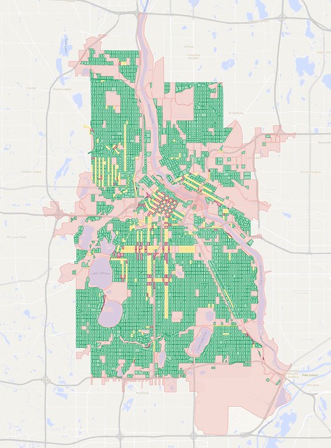

A map of city blocks in Minneapolis. Click here for full map.

In my maps, blocks that are less than 15 acres in size are colored green, yellow, or dark red (the latter two colors help indicate the presence of one-way streets). Blocks of 15 acres and larger are shown in pink. That size is roughly when I find that they become uncomfortable to walk around—these blocks have a circumference of at least 0.6 miles and take at least 12 minutes to circle on foot, and those numbers increase as blocks elongate and morph into strange shapes.

Minneapolis is a city of about 407,000 people, and has been getting built up for more than 150 years. A street grid system has been effective at filling out and giving access to most of the city's developable land. Areas shown in green on the map are generally pretty walkable and bikeable, with typical city blocks around four or five acres in size. Not all areas of the city have good access to things like restaurants, grocery stores, or other shops, but there's generally good connectivity, setting up a nice framework to be built upon.

My Minneapolis map has 4,701 small blocks compared to 225 large ones, for a ratio of about 21:1.

Now let's turn our gaze to Eden Prairie, which hangs off the southwestern edge of the I-494/I-694 beltway. It was incorporated in 1962, and has grown rapidly to become a city of about 63,000 people. An abundance of office parks and retail locations mean that close to 40,000 people work in the city, more than 85% of whom commute from other cities in the metro area. Like Minneapolis, most of the city's developable land has now been divided up into fairly small, privately-owned parcels, so it's almost fully built out:
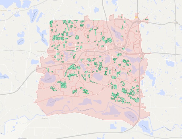
A map of city blocks in Eden Prairie, Minnesota
A map of city blocks in Eden Prairie. Click here for full map.

Um. Yikes!

This map has 328 small blocks and 164 big ones—a ratio of just 2:1, or less than one-tenth the small:big block ratio for Minneapolis.

In a word, this is sprawl. There's a lot more stuff in Eden Prairie than what that map shows, but it's arranged in ways that waste land and make it extremely difficult to get around by any means other than driving. Let's zoom in on a section near Baker Road and Valley View Road to get a better look at what's going on:
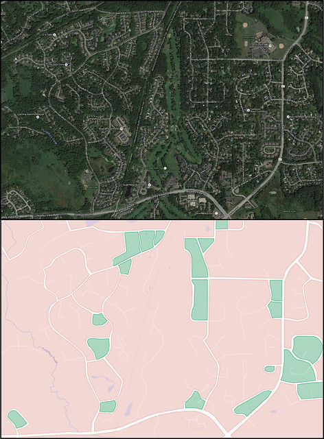

Comparing an aerial view of Eden Prairie to a map only showing city blocks.

This comparison image shows how the suburb's dead-end streets and cul-de-sacs fill up space but don't really contribute to street connectivity. Tracing only the block edge filters out most of the streets that are mere fingers into larger areas of land. The gaps between blocks mostly show through streets, though sometimes blocks exist in small pods that are entirely encircled by a larger block except for a single road to access them.

This map highlights how suburbs' heavy reliance on cul-de-sacs, pod-style development, and hierarchical road systems is bad for walkability and bikeability, and it isn't good for car traffic either.

Do you remember how busy things were at polling places on caucus night this year? My caucus site in Saint Paul was at a nearby school less than a mile away, and I was able to walk there in 15 minutes. While a lot of other people drove, the school I went to was surrounded by a pretty good street grid to walk, bike, and drive on. I'm sure there was some frustration with parking, but there were plenty of open spaces on nearby streets as long as people were willing to walk a couple blocks.

In Eden Prairie, by contrast, a much higher proportion of people had to drive to their caucus sites, and the limited number of alternate routes created cases where the traffic stretched on for long distances—perhaps miles:


The sparse road system in suburbs like Eden Prairie funnels traffic onto the few through streets that remain. A system of small streets connected to feeder streets leading to main arterial roads can create traffic jams that could be sopped up by the grid in more traditional neighborhoods.

The limited number of through routes also creates huge problems for transit planners. Buses operate most effectively when they can run on relatively straight routes to and through mixed-use zones. They can only pick up and drop off passengers along the edges of these blocks, unless a special right-of-way or station is built. Buses that run along the freeway can't stop wherever they want—they have to exit the freeway either on a normal off-ramp or using special bus-only access.

Finding a relatively straight route that manages to hit walkable pockets while also reaching relatively dense areas of population and useful destinations is difficult or impossible with this street layout.

In some cases, there are bicycle and pedestrian paths that break blocks up into smaller areas, but they aren't consistently in place from neighborhood to neighborhood. Single-use zoning is the norm, with residential, commercial, and retail spaces kept segregated from one another, so most paths don't really take you anywhere other than the local neighborhood. Such paths may be nice for recreation, but they aren't able to provide a suitable alternative to getting around the city by car.

Alright, enough picking on Eden Prairie. Let's find another point of comparison. How about Woodbury, a somewhat more populated suburb of about 67,000 that lies just one mile outside the city limits of Saint Paul:
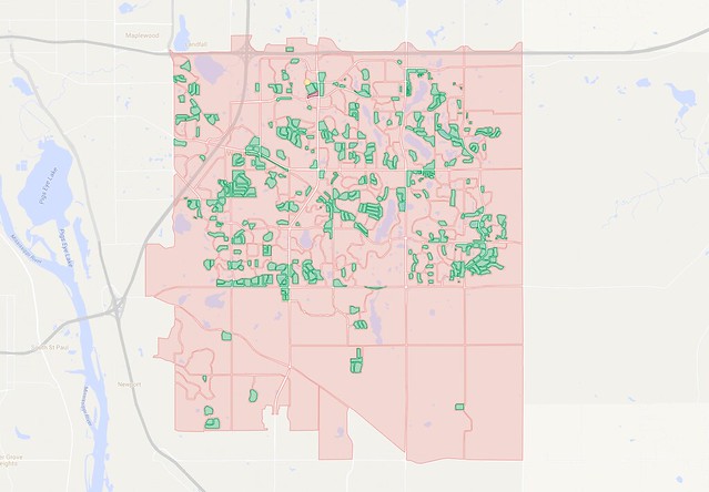

A map of city blocks in Woodbury. Click here for full map.

Oof.

Okay, by my measurement, there are 377 small blocks in Woodbury and 200 big blocks, for a ratio of about 1.9:1. That's slightly worse than Eden Prairie, though Woodbury's development remains somewhat restricted by the Metropolitan Council's MUSA urban boundary line. A fair amount of the southern and extreme eastern parts of Woodbury is still farmland, so there's some potential for the ratio of big blocks and small blocks to improve before it gets fully built-out, but only slightly if future development continues in the same way as what has preceded it. The area that has developed within the MUSA boundary seems a little denser than Eden Prairie, but not by much.

Both of these cities have completely rejected the street grid, and there's hardly a straight line to be found anywhere within them, with the exception of section line roads roughly one every mile in Woodbury. (They had little impact on the layout of neighborhood streets between them, though.)

Alright, let's try and find a suburb that's a little more ordered in its development. How about Bloomington, which lies just east of Eden Prairie. It has about 86,000 residents and is duking it out with Duluth for the rank of fourth-largest city in the state:
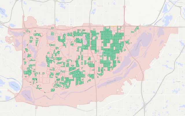
Map of city blocks in Bloomington
A map of city blocks in Bloomington. Click here for full map.

Aha! Here we have found something of a "missing link" in the transition between cities and suburbs in our metro area. Bloomington is technically an older city in the metro area, as it was incorporated in 1858. However, the number of people living there grew slowly until just after World War II. The population jumped from 3,600 to 9,900 between 1940 and 1950, then exploded to more than 50,000 in 1960 before leveling off at about 82,000 around 1970.

Bloomington lies south of Minneapolis and the inner-ring suburb of Richfield. The Minneapolis street grids extends through Richfield and is present in parts of Bloomington, particularly between Interstate 35W and Cedar Avenue (Minnesota State Highway 77). However, the grid is much more fragmented in Bloomington, and many blocks are considerably larger—essentially two to four Minneapolis-sized blocks merged together.

There's a certain logic to that, since the lot sizes for individual homes also grew as development moved pushed south and west through Bloomington. The most common residential lot size in Minneapolis is about one-eighth of an acre, while houses in Bloomington are typically on lots about two or three times that size. If a block size that formerly contained 30 homes could now only hold 15 or 10, it might make sense to bump up block sizes by a corresponding amount, in order to avoid creating too much infrastructure for too few people.

That alone might not have been so bad, but the city block structure also began to twist, turn, and break apart first as curving streets and then cul-de-sacs became fashionable among developers in the post-war era.

Lot sizes for commercial and industrial businesses also grew, and retailers were often concentrated into strip malls or shopping centers, all of which were major contributors to the weakening of the street grid. Even though many businesses have the same or similar amounts of square footage as comparable ones on smaller parcels in the core cities, they're separated into single-use buildings and surrounded by parking lots.

All of this helps explain why so few people walk, bike, and take transit in the suburbs as compared to Minneapolis. The idea of a standard city block is completely alien in these areas, and people can live their whole lives without really understanding what it's like to live in a true neighborhood where it's possible to live, work, eat, shop, and do most other things without needing to get on a highway.

As Nick Magrino noted in his Measuring the Metro Area and Getting Real with the Map piece, only the core cities and a limited set of the suburbs can be considered "urban" in a traditional sense. Without the framework of a tight grid or other small-block layout, it becomes nearly impossible to meet or even set meaningful goals for increasing mode share for walking, biking, or taking transit, and it makes it extremely challenging to serve populations like children, the elderly, or those with disabilities who can't move themselves around by car.

While developers have occasionally tried to go back to smaller block sizes in what I like to call "New Urbanish" projects, they are still often isolated in small pods. Going back to the grid is one of the only ways to break developers of their bad habits. But are we already too late?
Wednesday, April 20, 2016

Getting around the block: City vs. city


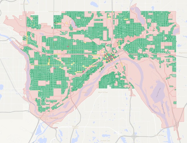
A map of the city blocks of Saint Paul. Click here for full map.

In my previous post, I compared the city block layouts of the downtowns of Minneapolis and Saint Paul. This time, I thought I'd zoom out and compare the whole cities. Above is the map for Saint Paul, a city of about 300,000 residents. Blocks that are green, yellow, and dark red are smaller in size, less than 15 acres, while pink blocks are larger. That's a fairly arbitrary size to mark a transition between small and large blocks, but generally fits with where I'm comfortable getting around. A 15-acre block is at least 0.6 miles in circumference, taking about 12 minutes to circle on foot, with the time and distance increasing as blocks get longer, thinner, and begin to take on strange shapes.

In general, the map shows blocks of the tightest loop you can make with surface streets to circle around any particular point in the city. Some of these blocks extend well beyond the city borders, so these maps make the cities look a bit larger geographically than what you normally see. To simplify my mapmaking, I generally required streets to have car and bike and pedestrian access, which excluded freeways (illegal to walk or bike on) and made campuses and parks look less permeable here than they would be to someone using non-motorized transportation.

The color coding helps indicate the presence of one-way streets and how they impact navigation by car (usually with the same rules applying for bikes). Green blocks can be circled clockwise, while yellow and dark red blocks have one-way streets on their edges that either require at least one left turn (circling the block counter-clockwise), or have turn conflicts that prevent looping the block.

As I noted in my last post, downtown Saint Paul is relatively isolated from the rest of the city, but a dense street grid reaches through most other neighborhoods, creating large, fairly contiguous regions that are fairly easy to walk and bike around, and that can sop up large volumes of car traffic.

Individual neighborhood "islands" contain scattered large block within them, and are separated from each other by longer corridors. The city's network of highways and railways also fans out from the downtown area through the rest of the city. These tend to run past industrial and low-density commercial blocks, but also sometimes bump into other areas of limited development.

Many large blocks appear because of natural impediments like rivers, lakes, and steeply sloping hills. The Mississippi River valley marks the most significant area of big blocks through the city, with wide river flats areas that are largely un- or under-developed. The West Side Flats area just across the river from downtown is notable for getting its residential population cleared out in the 1960s after flooding devastated the area the decade before. However, the low-density commercial development that replaced it still contributes to downtown's isolation from the rest of the city.

Some large blocks on the map are fairly private spaces like cemeteries and golf courses, while others are more permeable to foot and bicycle traffic, such as parks and school campuses.

The relatively sparse road network on the western edge of Saint Paul creates a large lobe extending well into Minneapolis along BNSF rail corridors.

I mapped out 3508 small blocks and 248 large blocks in Saint Paul, which is a ratio of about 14:1. Let's take a look at Minneapolis and see how it compares:


A map of city blocks in Minneapolis. Click here for full map.

Minneapolis is somewhat larger and denser than Saint Paul, with a population of about 407,000. Regions of small blocks are even more contiguous than in Saint Paul, perhaps aided by the fact that the city is a bit flatter than its neighbor to the east.

Interestingly, the Mississippi River channel is narrower through Minneapolis (the city sits upstream of the confluence with the Minnesota River). It's also a bit harder to see freeways cutting through the city than I would have expected.

One-way streets extend much farther into Minneapolis's neighborhoods than into Saint Paul. Some of these one-ways essentially make highways through town, while others are in place because of narrow streets or heavy volumes of parked cars in denser neighborhoods.

Railroads still cut through parts of the city, particularly in paths radiating to the west of downtown and in through Northeast and Southeast Minneapolis, but they don't have quite the same impact as in Saint Paul. The areas northeast of the Mississippi also host a large amount of industrial land along Interstate 35W and the rail corridors. Surface streets are so limited in that area that the convergence of I-35W, Minnesota State Highway 280 and MN-36 creates a "block" that extends all the way to Fairview Avenue—kitty-corner to Rosedale Center mall.

Similarly, the sparse road network along the I-394 corridor creates blocks that extend well into St. Louis Park and Golden Valley, even reaching past MN-100. That same highway makes a significant barrier on the northeastern edge of the city, so circling on surface streets would take you through parts of the old Brookdale Mall in Brooklyn Center.

Circling the block along the MN-62 corridor on the south end of Minneapolis will take you into Richfield, and a large lobe also extends south of the city to encircle Minneapolis–Saint Paul International Airport, which takes up most of the unincorporated area of Fort Snelling.

When making this map, I was surprised at how many blocks were crammed close to Lake Harriet, Lake Calhoun, and Lake of the Isles. Even areas around Lake Nokomis and Diamond Lake have had a lot of stuff built quite close to them.

Planners in Minneapolis have used the street grid and other small-block layouts to great effect since the city was founded, filling almost every nook and cranny they could find. I count 4,701 small blocks on this map, plus another 225 big blocks—a ratio of nearly 21:1 (significantly higher than Saint Paul's 14:1).

How do you think the suburbs fare in comparison? Stay tuned for a future post.

Monday, April 18, 2016

Getting around the block: Downtown vs. downtown


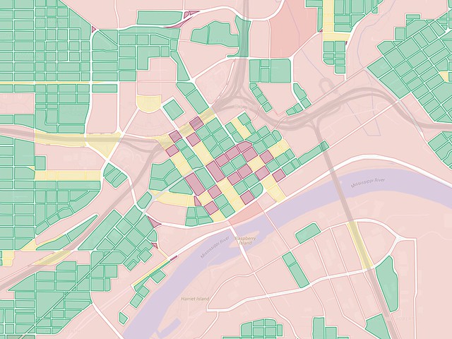
Map of city blocks in downtown Saint Paul. Click here for full map.

How hard is it to get around the city block where you live, work, or shop? Does that affect the modes of transportation you choose on a daily basis? Does it impact the choices of city planners, or the areas where businesses choose to locate?

Until I started working in downtown Saint Paul, I often avoided the area due to its reputation for getting people lost. There are several one-way streets that create confusion, and the north-south streets are mostly named rather than numbered, so it becomes difficult to keep track of where you are unless you know the pattern. Take a wrong turn, and a driver can inadvertently get sent across one of the long bridges that separate downtown from other neighborhoods.

The streets aren't just an issue for drivers, though. Cyclists are also supposed to ride on the street and take the same circuitous paths as cars (unless you cheat by riding on the sidewalk). Even walking is impacted—I often use the green traffic light as a backup for knowing when to cross, since many pedestrian signals don't activate automatically, but car car signals aren't visible on some corners of one-way intersections.

Recently, I started mapping downtown to try and represent these navigation difficulties, starting with how hard it is to turn where and when you want to. I used green for blocks that can be circled in a clockwise direction with right-hand turns when driving. Yellow blocks mean that one-way streets on at least one side require turning left to make it all the way around. I used dark red for blocks where at least one turn would send you into oncoming traffic—those blocks require you to include at least one other block when circling around.

However, a different pattern began to dominate as I moved away from downtown and into the nearby neighborhoods. "Big" city blocks also create an impediment to navigating the city. The most obvious boundary around downtown is the Mississippi River, but there are highways, railways, and other underdeveloped spaces that almost completely isolate downtown from other neighborhoods. I used a threshold of 15 acres to distinguish "big" blocks (shown in pink) vs. "small" blocks—a number I arrived at for little more reason than 10 acres seemed too low and 20 acres seemed too high.

A square block of 15 acres has a circumference of about 0.6 miles, taking about 12 minutes to walk around, and the time and distance increases as blocks become more rectangular or otherwise elongated. Of course, some smaller blocks can take much longer than 12 minutes to circle on foot due to strange shapes, and the presence of small blocks doesn't automatically mean that you're in a walker's paradise. But in general, I think the resulting maps give a good indication of what it's like to get around.

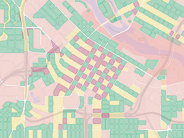
Compare the above map of downtown Saint Paul with another one I made of downtown Minneapolis. This shows a fantastic checkerboard pattern of blocks that can be circled clockwise, counterclockwise, and the ones that have turn conflicts requiring extra circling of adjacent blocks.


Map of city blocks in downtown Minneapolis. Click here for full map.

Both downtowns have significant "moats" around them, though downtown Minneapolis retains more connections to nearby neighborhoods, especially to the south. In both cities, highways (especially interchanges) make large unwalkable zones, though the straighter mainline sections of the highways aren't quite as bad. Saint Paul significantly tore down a large amount of housing in the West Side Flats area in the early 1960s, and the city's Port Authority redeveloped it as a low-density industrial park. Large areas were also torn down to free up room for the capitol grounds. The park-like capitol lawn is an impressive space, but opening up the area in that way created something more similar to a suburban office park than a downtown zone.

Saint Paul is also much more heavily affected by railroads than Minneapolis is today. Both cities used to have a lot of railroad activity downtown, but only one freight rail corridor still cuts through the center of Minneapolis today, in the Warehouse District on the edge of downtown. On the other hand, Saint Paul sits at the a convergence point of six or seven different railroad lines operated by three different freight companies, including two major transcontinental rail corridors. In the heyday of passenger rail, this was good since it allowed lines to branch out in any direction, but with passenger service almost completely wiped out today, the freight lines present a significant burden on the downtown area.

This map likely helps explain how the West 7th Street neighborhood is one of the most active areas in/near downtown, since it's one of the only continuous connections of smaller, more walkable blocks leading into downtown. The only other similar link is along Robert Street and Jackson Street on the north end of the city—an area dominated by government buildings and a hospital.

Downtown Minneapolis blends into nearby neighborhoods more readily, though there are still significant gaps. I skipped over freeways when making these maps, since it's illegal to walk or bike along them except in limited circumstances, but also avoided routes that are only for bikes or pedestrians. That's mostly just to keep the maps relatively simple—many bike and pedestrian connections are hard to see on maps, and they more frequently involve bridges, which lead to some trouble when mapping. Sometimes a single spot can be encircled by several different "blocks" depending on which bridges or other links you choose to use—I've included some of those, such as on Nicollet Island in Minneapolis, but tried to limit my use of overlapping blocks to keep the maps cleaner.

What stands out to you about these maps? Do they match the way you feel about the ease or difficulty of getting around these parts of town?