Monday, September 21, 2015

Getting rolling on rail to Eau Claire

This week, a citizen group is holding a couple of public meetings to advocate for a passenger rail link between the Twin Cities and Eau Claire, Wisconsin, a corridor that MnDOT suggested in its 2010 State Rail Plan should be built before the year 2030.
The meeting announcement has led me to dig into the route and do some analysis of my own, though this doesn't necessarily reflect what will be presented by the St. Croix Valley Rail Group on Wednesday.


MnDOT's plan suggested a regional rail service operating approximately four round-trips through the day, though presumably they would be spread out, making it unlike peak-only commuter rail service. (Commuter rail had been studied and discarded on this route as part of the Gateway Corridor study, which is instead looking at bus rapid transit for the much shorter Gold Line route).


Wisconsin's Department of Transportation had also been working on a 20-year rail plan around the same time as Minnesota, though it was put on pause following the Tea Party-infused political surge later that year which put Governor Scott Walker in office alongside a much more conservative legislature in the winter of 2010–2011.

Wisconsin then ended up with a near-total abandonment of passenger rail planning. The official state rail plan document was finally approved last year, and includes possible links to Eau Claire, Madison (where federal funding was famously turned down by the state), and Green Bay.

That's good, but a bit underwhelming, considering how Wisconsin's population is less heavily concentrated than Minnesota's (see this map of cities with populations greater than 5,000 and contrast it to the one for Minnesota), so I expected a couple of other interesting links. These seem to be cribbed from older Midwest Regional Rail Initiative plans, a multi-state effort for high(er)-speed rail that was once led by Wisconsin.

Wisconsin's rail plan for the year 2030 includes possible connections to Eau Claire, Madison, and Green Bay.
One significant link that seems like it's missing is some sort of connection from Eau Claire to Green Bay. Frustratingly, the most direct link via Wausau has been mostly abandoned at this point, though it would still be possible to have a fairly good path through Stevens Point and Appleton (which might make it a better idea anyway).

But for this post, I want to focus on Eau Claire, which lies about 100 miles east of Minneapolis. The city itself only has a population of about 65,000, though there are a number of nearby towns including Chippewa Falls which creates a small metro area of about 165,000 people. Menomonie is also close by, and the Eau Claire-Chippewa Falls-Menomonie Combined Metropolitan Statistical Area now reaches a population of almost 210,000.

Eau Claire and Menomonie (at nearby Menomonie Junction) had rail service on the Chicago & North Western Railway's Twin Cities "400" until July 23, 1963, about 8 years before the introduction of Amtrak. A timetable from 1962 listed travel time at 114 to 120 minutes from Minneapolis to Eau Claire and 85 to 90 minutes from St. Paul to Eau Claire (the eastbound train was slightly faster, at least on paper).

This was one of the three fastest trains to run between the Twin Cities and Chicago, although it had the major flaw that it only ran once per day per direction. That made it very hard to compete with automobile and air travel. Even today, Eau Claire has two daily round-trip flights to Chicago, subsidized through the Essential Air Service program (though they will still cost you more than $350 round-trip).

Restoring passenger rail service on the corridor has the potential to provide a more frequent transportation option for the area's population while also reducing costs, especially compared to flying: The existing Eau Claire air service costs close to 70 cents per mile when EAS funding is included, while the average cost for Amtrak to carry a passenger one mile is about 40 cents (also including their subsidy).

It's certainly a bit tough to imagine reestablishing service that was abandoned by the railroads more than 50 years ago now, though it's important to note that Wisconsin's population has grown by 40% since 1963, and Minnesota's has grown by 55%. Even if the potential market for rail service remains relatively small, it continues to grow year over year.

So, what are the challenges facing restoration of service on this line? Here's a map I put together of single-tracking and sidings along the corridor, to give an idea of the route's capacity:


Between Saint Paul and Eau Claire, there are only four places with long sidings or segments of double-tracking, plus another short siding at Menomonie Junction, which limits how often trains can pass each other. It's 38 miles between the double-tracked segment in Hudson eastward to Menomonie, according to Google Maps' "Satellite" view, and about 46 miles from Hudson to the longer siding near Elk Mound. [Update: It turns out that I missed a siding between Woodville and Hersey, which reduces the longest stretch of single-tracking to 21 miles.]

MnDOT's rail plan only suggested running four round-trips per day (eight total trains), and the Federal Railroad Administration's Highway-Rail Crossing Inventory suggests that there are only about four freight trains per day, so with appropriate scheduling, it's conceivable that 12 daily trains (less than one per hour) could operate over that gap without needing any new infrastructure. Still, it would be better to add a few new sidings to shorten the gap. Even with upgraded track speeds, passenger trains could take half an hour to 45 minutes to cover the gap, and freights could take more than an hour, potentially leading to serious delays on trips that should only take two hours end-to-end.

A few additional sidings would be a good idea, likely including one near Baldwin to be about halfway along the line. There are also clusters of freight customers near Menomonie and Truax which should have their spurs connected to shared sidings. That would allow the main track to be kept clear for through traffic while freight crews deal with the relatively slow process of attaching and detaching rail cars at the customer sites.

Much more of the line used to have double-track and sidings, but it was pulled out over the decades as freight traffic consolidated onto fewer routes and the need to keep extra track for passenger service disappeared. This means that there are few physical obstacles to restoring it, but it will cost a considerable amount of money. Each siding would likely cost several million dollars.

The tracks have also been allowed to degrade over the years, so the allowed train speeds are not as high as they once were. Freight trains can reach a maximum of 50 mph on the route, but only for a few short segments, according to a 2007 Union Pacific timetable I scraped off the Internet a few years ago. 85% of the route was limited to 30 mph or less at that time, though things may have changed since then.

The timetable notes that passenger trains are allowed to go 10 mph faster than freights on the line, but that doesn't help much when comparing it to the nearby Interstate 94 which has recently been updated with 70 mph speed limits (increasing from a rural freeway limit of 65 mph that Wisconsin had for many years).

Restoring tracks to 79 mph service, the typical standard for passenger service in the U.S., or beyond into "high-speed" territory will require an investment of a few hundred thousand dollars per mile. This type of work involves removing worn-out ties/sleepers, refreshing track ballast, and smoothing and straightening the rails themselves. Depending on the age and quality of the rails, they may only need to be run through a grinding machine to restore a good running surface, but bad segments would obviously need to be replaced.

The line is in relatively good shape as far as signaling goes, but would still need to be significantly improved for passenger trains to run on the route. The line has automatic block signaling (ABS) in place for all but about six miles of track, but future passenger lines are required to have positive train control (PTC). It's unclear how much that would need to cost, since it is still a new technology and price estimates have fluctuated wildly over the past few years.

That's a major hurdle, though the freight company may be required to implement it anyway if it carries hazardous materials on the route. If that's the case, then adding passenger service back on the route would be beneficial to the railroad, since the costs could be shared between the freight and passenger operations (with passenger trains most likely being funded by state and local governments, though the possibility of a privately-funded operation probably shouldn't be discarded entirely).

If the line is extended beyond Eau Claire as shown in the Wisconsin Rail Plan map above, the challenges would be similar for the next 120 miles of track. However, the last nine miles between Wyeville and Camp Douglas (where the line could merge with today's route of the Empire Builder) deserves special note: That section of track appears to be disused and in danger of abandonment. Google's aerial images show the right-of-way in a condition of poor repair, and miles of underused rail cars were parked there for long-term storage when pictures were taken.

That's yet another reason why planning of passenger service to or through Eau Claire needs to get going right away, before those tracks disappear.

The St. Croix Valley Rail Group is planning two presentations for Wednesday, September 23rd. I haven't had any direct contact with the group, but thought the timing presented a good opportunity to do some of my own digging. The meetings are scheduled at 5:30 and 7:00 pm, respectively:
River Falls Public Library
140 Union St
River Falls, WI
5:30 pm

Hudson House Grand Hotel
1616 Crest View Drive
Hudson, WI
7:00 pm
Wednesday, September 9, 2015

Sunset Unlimited: Restoring passenger rail on the Gulf Coast

Up here in Saint Paul, the Mississippi River passes within blocks of where I live and work. As the tenth anniversary of Hurricane Katrina approached, I started looking toward the other end of this waterway that links the Midwest to the South because I wanted to better understand the lasting impact of the storm on one of my interests, the nation's passenger rail system. Ever since the hurricane happened, service on Amtrak's Sunset Limited route has been suspended east of New Orleans, and the reasons why haven't been well-defined.

What could have damaged tracks so badly that it would still be out of service ten years later? Even though Katrina was the deadliest storm to hit the U.S. since 1928, was its impact so great that we couldn't restore the modest service that was running before the storm? In reality, the hurricane is probably just a convenient excuse for the halt of passenger operations and not an outcome that should be tolerated.

Surprisingly, when Amtrak formed in 1971, the system didn't include any service between New Orleans and northern Florida. It took over two decades of campaigning by the region before a direct link was reestablished in 1993. Even when the train did run on the line, it was only three times a week each direction—the same frequency that it's always had on the route's western section from Los Angeles to New Orleans.

I decided to take a look at the layout of tracks along the route to try and understand why it has continued to take so long, using a map format like what I used on the Empire Builder route several months ago. I focused on the 770-mile stretch that is still suspended between New Orleans and Orlando.


When I started, I expected to find something obviously out of place along the route, but as I traced the line through Louisiana, Mississippi, Alabama, and Florida, everything seemed to be in good order.

However, it was obvious from the aerial imagery that there were a few different sections to the corridor which carry different amounts of traffic and are maintained to different standards. I compared my map to railroad crossing data from the Federal Railroad Administration (which I used to make the map in my previous post) and made note of these five main segments:
  • Starting from the west, the Sunset Limited used mainline tracks that run from New Orleans to Mobile, Alabama, and then toward Montgomery, though the train turns off the mainline in the small town of Flomaton, Alabama, right next to the border with Florida. For this distance of about 210 miles, the track see about 15 to 18 freight trains per day. The FRA railroad crossing database still lists top speeds up to 79 mph, which is the maximum for most passenger rail lines across the U.S. The longest distance I found between sidings was 13.8 miles.
  • From Flomaton, the line heads south to Pensacola, Florida and then east to Tallahassee, covering a distance of about 240 miles. This section of the line is much quieter, only seeing two or three trains per day. Speeds appear to range from 30 mph up to 59 mph, a number that signifies that the line lacks any illuminated signals to help control train movements. The longest distance between sidings here is 31.1 miles
  • For the next 105 miles from Tallahassee to Lake City, there are about 7 trains per day, and top speeds now appear to be about 40 mph in most places (which appears to be a reduction in speed from before the storm in 2005). The longest stretch between sidings is 18.4 miles.
  • The 62 miles from Lake City to Jacksonville host 8 to 12 trains per day and have speeds up to 79 mph, with the longest single-track segment being 12.5 miles.
  • The 151 miles from Jacksonville to Orlando still has three Amtrak passenger trains in operation, the Silver Meteor, Silver Star, and the Auto Train (an oddball route that only stops in the Orlando suburb of Sanford). The FRA data indicates there are 8-14 trains per day in total, though it doesn't seem to include traffic from the new SunRail commuter service near Orlando. the spacing between sidings is fairly short, only reaching up to 11 miles apart. Most of the commuter rail section near Orlando is double-tracked.
CSX Transportation is the railroad that owns the tracks all the way from New Orleans to Orlando (the western segment of the train that is still in operation is run on Union Pacific tracks from Los Angeles to Lake Charles, Louisiana, where it switches to BNSF tracks for the rest of the route to N.O.). Their heaviest damage in the storm was between New Orleans and Mobile.

Just east of New Orleans, the tracks cross the Intracoastal Waterway, which connects Lake Pontchartrain to the Gulf of Mexico. The line then passes into Mississippi and through communities such as Bay St. Louis, Pass Christian, and Biloxi, which were among the places hit hardest by the wind and storm surge during the hurricane. In Pass Christian, the surge measured 27.8 feet and was combined with a relatively high tide.

That level of surge is enough to completely obliterate homes and other modest-sized buildings. The rail line suffered too as tracks were washed out and bridges destroyed and electrical signaling huts that were flooded with saltwater as the water crashed ashore. In some places, ships and barges floated up onto the ground and eventually settled onto tracks as the waters receded.

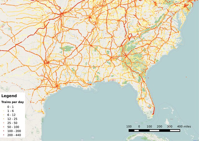
Map of train traffic volumes at grade crossings in the southeastern U.S.

About 100 miles of track was severely damaged or destroyed, but with 15 to 18 trains per day, it was important for the railroad to be repaired and brought back into service. The railroad and several contracting companies worked for four months to restore service between New Orleans and Mobile.

It's less clear how bad the situation was in Florida, along the second notable section of track in my list. Pensacola did experience a modest storm surge of about five feet, but that didn't cause as much damage, so the line was back in operation pretty quickly. Only the track nearest Pensacola would have been affected by storm surge—most of the distance from Flomaton to Tallahassee is inland and would have only been damaged by wind and creeks and rivers swollen by rain.

And yet, this relatively protected stretch of track is probably the real culprit preventing the resumption of service. With only two or three trains per day, there isn't enough revenue from freight traffic to warrant maintaining tracks at the level that passenger trains really need.

I was surprised to see that train frequencies were so low along that stretch of track, since the Gulf Coast seems like an important economic region to me. But rail freight tends to move in a more hub-and-spoke pattern like airlines rather than a point-to-point service like highway vehicles do.

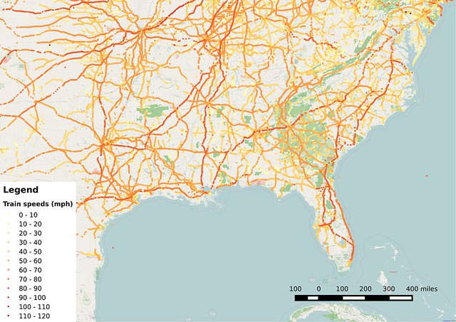
Map of train speeds at grade crossings in the southeastern U.S.

A line with just two or three freights per day often only justifies enough maintenance to operate at speeds of 10 to 30 miles per hour, which is far too low for passenger services. Extra outside funding is often needed to cover the cost gap when passenger operations exist on otherwise quiet lines. That's likely one of the reasons why Sunset Limited service hasn't resumed: Either previous funding sources dried up, or the railroad increased the amount of money they were asking for after the hurricane and subsequent repair work.

Running more trains, whether freight or passenger, would allow the cost to be spread more widely, but that idea hasn't gotten much traction so far. Amtrak studied the route back in 2009, but only looked at either restoring the previous tri-weekly train or two options for running a daily service (one was an extension of the City of New Orleans from Chicago, while the other was a standalone New Orleans to Orlando train).

Amtrak's underwhelming conclusion? Restore the train as it had been before, despite it's infrequent service and all the delays and complication involved in running a train all the way from coast to coast.

Studies like that are asking the wrong question and getting the wrong answer. What the country really needs is for Amtrak to add frequent, speedy service so that their trains can be used as day-to-day transportation for many more people. That would broaden the benefits that the company provides, and hopefully reduce their operating losses as well.

Here are populations for some of the metropolitan areas from New Orleans on east to Orlando:
  • New Orleans region - 1.2 million
  • Gulfport region - 383,000 
  • Mobile region - 414,000
  • Pensacola region - 461,000
  • Tallahassee region - 376,000
  • Jacksonville region - 1.4-1.5 million
  • Orlando region - 2.3-3.0 million
It's about 620 miles from New Orleans to Jacksonville, the longest gap between 1-million-plus metros on the corridor. That's considerably longer than the 400-mile rule of thumb used in rail planning, though there are a lot of people questioning whether that's a valid rule.

Still, there are a few shorter segments that look good on paper. Here in Minnesota, we've been looking at adding eight daily round-trips on the 150-mile Northern Lights Express corridor from Minneapolis to Duluth. The Twin Cities has a population up to 3.5 or 3.8 million, and the Duluth area has a population around 280,000.

Orlando and Jacksonville two 1-million-plus metros about 150 miles apart, which makes that corridor an ideal candidate for increased rail service. New Orleans-Gulfport-Mobile and Jacksonville-Tallahassee are also pretty similar distances (144 and 167 miles, respectively).

Having multiple daily trips on the eastern and western segments would probably improve the viability of the middle section of the line, the most likely source of trouble today. The service improvements might even justify a new, more direct rail alignment between Mobile and Pensacola.

Similarly, if we look to cities west of New Orleans, there are some interesting combinations possible if the line started in Texas:
  • Baton Rouge region - 820,000
  • Lafayette region - 479,000 to 616,000
  • Houston region - 6.3 million
  • San Antonio region - 2.3 million
Houston to New Orleans is about 363 miles, which makes puts it in that ideal distance zone for frequent, high-speed service. Houston is also a notable destination because the Texas Central high-speed rail service is being planned to connect that city to the Dallas-Fort Worth metroplex. Frustratingly, a segment of track between Lafayette and Baton Rouge has been abandoned, so it would take some significant investment to link that city, but it would be worthwhile in the long run.

Amtrak's trouble with restoring the Sunset Limited or pursuing even better options shares the same symptoms that the company has all across the country. They've lacked the funding and motivation to pursue service improvements in areas that would bring the biggest bang for the buck while also adding to the system's overall connectivity. Amtrak needs better funding to pursue these opportunities, otherwise we'll look back in a couple decades and still find a skeletal national network that hardly looks different than what we have today.