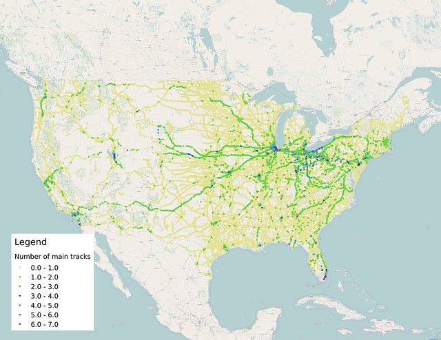
Here's a map I put together using the Federal Railroad Administration's Highway-Rail Crossing Inventory database, focusing on the number of main tracks at public grade crossings across the country. The main thing to see is that the vast majority of our rail infrastructure is single-tracked, only allowing trains to travel in one direction at a time on segments of track that don't have passing sidings. (For this version of the map, I didn't attempt to show sidings.)
There are only a dozen or so major double-tracked corridors that show up on this map. Some routes, like the double/quadruple-tracked Northeast Corridor between Washington, D.C. and Boston, Massachusetts, are mostly or wholly invisible, since they are grade-separated and don't have any level crossings. Many metropolitan areas and rail hubs have splotches where there are three or more tracks, but they're usually for very limited distances.
Some rail routes are double-tracked due to running heavy, slow trains. This includes routes in northern Minnesota that were built to haul iron ore/taconite to seaports on Lake Superior. In Wyoming's Powder River Basin, the triple-tracked Joint Line shows just a few public crossings. It's used to haul coal out from the region's mines to connecting routes, some of which are themselves double-tracked.
BNSF's Southern Transcon connecting Southern California to Chicago shows up particularly well—it's a route that carries a lot of intermodal traffic from West Coast ports. Union Pacific's corridor between Northern California and Chicago doesn't show up quite as much—for some reason, there aren't many crossings shown out west, though it also has more single-tracking.
Routes that have a significant amount of double-tracking correspond pretty well with maps of Amtrak service. Out west, the Amtrak Cascades corridor is easily visible between Oregon and Washington, and the Capitol Corridor stands out in California. Other long-distance routes in the Eastern U.S. and Midwest also show up pretty well: The route of the City of New Orleans, the Crescent, and the Silver Star (which shares parts of its route with a couple other long-distance Amtrak services).
Double-tracking isn't a requirement for passenger routes, but double-tracked lines make scheduling much more flexible and can dramatically increase capacity over lines that only have a single main track. Single-tracked lines are constrained in the number of trains they can carry by the number of sidings, spacing between them, and siding length, not to mention the general condition of the line and other design features that limit train speeds.
Most rail maps of the United States don't differentiate between busy and lightly-used rail lines, in contrast to maps of the highway system which are able to classify roads based on design. Each can be misleading, though—just as a busy rail line doesn't look much different than a quiet one, it also isn't obvious from the design that that Interstate 94 is far busier in Wisconsin than it is in North Dakota or Montana.
In Nevada, the UP route from NorCal to Chicago uses the former Southern Pacific and Western Pacific routes, each single-tracked, as an ersatz double track.
ReplyDeleteAwesome map. Thanks.
ReplyDeleteI was trying to figure out where the short list of many-many-track crossings (5 tracks and up) were, but I had too much trouble with the data -- any chance you could find out?