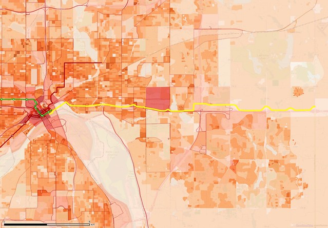
The preferred alignment of the Gold Line/Gateway Corridor running eastward along I-94 from downtown Saint Paul overlaid on a map showing population and employment density as well as other transit routes.
Last Tuesday, the Lake Elmo city council voted 3–2 to reject further involvement in the Gold Line project, also known as the Gateway Corridor. The service has been planned to run through 2.5 to 3 miles of Lake Elmo, but that would take it through some undeveloped areas with very low population density and limited amounts of commercial development. I've been disheartened to see planners push this strange routing, so I see this rejection by Lake Elmo as an opportunity to restore some sanity to a project that has literally gone off in the wrong direction.
The Gateway Corridor only came onto my radar around 2010, but it has moved through the local planning processes relatively quickly. Of course, with some of our regional transit planning efforts taking decades, it's not that hard to stand out.
When it was first talked about, the Gateway Corridor included a study area extending all the way to Eau Claire, Wisconsin (more than 80 miles from downtown Saint Paul). It has been trimmed back and is now shortened to about 12 miles—Still a mile longer than the Central Corridor! The currently preferred alignment runs from Saint Paul through Maplewood, Oakdale, and Lake Elmo, likely with a turn at the very eastern end south into Woodbury (not included in my map).
Rail and bus options have both been considered for this line, but the rail options have been discarded at this point. It's currently expected to be built as a bus rapid transit service with a dedicated busway (similar to the route used by the University of Minnesota's Campus Connector buses).
(MnDOT still has a separate plan to run regional rail service to Eau Claire on the drawing board, though it's not clear when planning for that route will pick up steam again.)
An eastward transit service along the Interstate 94 corridor has been on the minds of planners for decades, particularly due to 3M's global headquarters in a mile-wide section of Maplewood just outside of Saint Paul. It's home to around 12,000 employees, but only two bus routes, the 219 (suburban local) and 294 (express), reach the corporate campus today.
It makes sense to improve service to such a major destination, but I've been continually baffled as Gateway Corridor planners have stuck so close to I-94, seemingly a vestige of the original plan to reach cities in Wisconsin. I was even more surprised when they pushed for building large segments in Lake Elmo on the north side of the highway, a suburb that has fought against denser development.
Lake Elmo has a sizable population of over 8,000, but because it is a community that annexed most of its surrounding township, those households are spread across more than 22 square miles of land. Small towns out in rural parts of Minnesota often have densities of 1,000 to 2,000 people per square mile, but Lake Elmo only tips the scales at 360 per square mile.
There has been a lot of development in the city but it's very spread out because homes are typically placed on large parcels that are two acres or larger in size. Amusingly, the densest blob of population in Lake Elmo is the Cimarron trailer park near Lake Elmo Avenue and 10th Street North.
Woodbury, just to the south across I-94, stands in stark contrast to Lake Elmo. While Woodbury isn't nearly as dense as the central cities of Minneapolis and Saint Paul, it has an estimated population of nearly 67,000. It has no traditional downtown that I'm aware of, and was only incorporated in 1967, but has seen explosive growth over the last few decades. It is an almost perfect example of 36-square-mile township becoming an incorporated city, though not quite 2/3rds of its area has been actively developed so far.
Neither of these cities is a poster child for dense development, but Woodbury has at least experimented with more urban patterns, such as at City Walk near Woodbury Drive and Hudson Road.
Personally, I don't understand the desire to route such an expensive service (currently estimated at $485 million) into almost completely undeveloped area where the local government is hostile to any reasonable density. It could easily go south of the highway through an existing retail corridor—still very under-developed, but hopefully a region that would be more easily fixable with the right incentives in place.
But even with the Gold Line running south of I-94, is that enough to fix the current transit situation out in the eastern suburbs? Metro Transit barely gets into Woodbury today, only serving a small area in the northeast corner of the city, and only operating express bus routes with limited schedules. While the Gold Line would add more stops and an all-day schedule, the stations would all need to be built around the park-and-ride model. While that would probably work alright for workers in downtown Minneapolis or Saint Paul, I have a hard time imagining anyone would use a park-and-ride stuck next to I-94 in order to get to 3M, a destination that's only a few minutes away on the highway.
The Gateway Corridor really needs to morph into something different—a network that gets a lot more people within walking or biking distance of their nearest stop. If Woodbury was a standalone city, it would be big enough to justify its own transit system. Woodbury has a population comparable to St. Cloud, and is around the size that Rochester was when I was growing up, and both have modest bus systems. While the city doesn't have a traditional layout with a downtown to act as an obvious hub, it is roughly laid out along mile-by-mile grid with fast arterial streets that would automatically encourage a limited-stop style of service.
Here's an example of a simple network that could be built out of a half-dozen routes or so to allow local connectivity while also bringing traffic north and west to connect to the existing Metro Transit network. It gets most of the city within half a mile of a bus stop. In a few places, I routed lines along bikeway corridors or created other new routes (such as a bridge crossing just west of the I-94/I-694/I-494 interchange), but it's likely that such a system could be put together for much less than the current estimated Gold Line price.
Obviously, Woodbury's low density would be a challenge for successfully implementing a network like this. I just slapped this network together quickly by following major roads, but I think it has a few features that would be critical for success. First, I had four routes converge on the 3M campus northwest of the city, fanning out through the city in different patterns. Second, multiple routes converge at two other hubs: Woodbury Village by I-494 and Valley Creek Road, and Tamarack Village on Radio Drive just south of I-94.
Purely as an example, the purple line extends down Radio Drive all the way to Cottage Grove, since I think there's a slim possibility of decent suburb-to-suburb service (in this case, perhaps a link between the Gold Line corridor and the Red Rock service proposed along US-61). There's also some potential here to link to routes along I-494 to cross the Mississippi River into South St. Paul and other southern suburbs.
Before I end, I'll point out another huge challenge that Woodbury must overcome to rebalance its transportation network. The city has a dearth of decent pedestrian infrastructure, with sidewalks and sidepaths largely restricted to major roadways—and sometimes only running along one side of those roads. Here is a sidewalk map from the folks at ITO—green roadways are the only ones that have sidewalks, while red roadways don't have any pedestrian infrastructure (pink indicates actual sidewalks, which is a little confusing, and light green indicates dedicated paths that aren't located next to a roadway—the awkward color scheme is a downside of using this otherwise wonderful free tool).
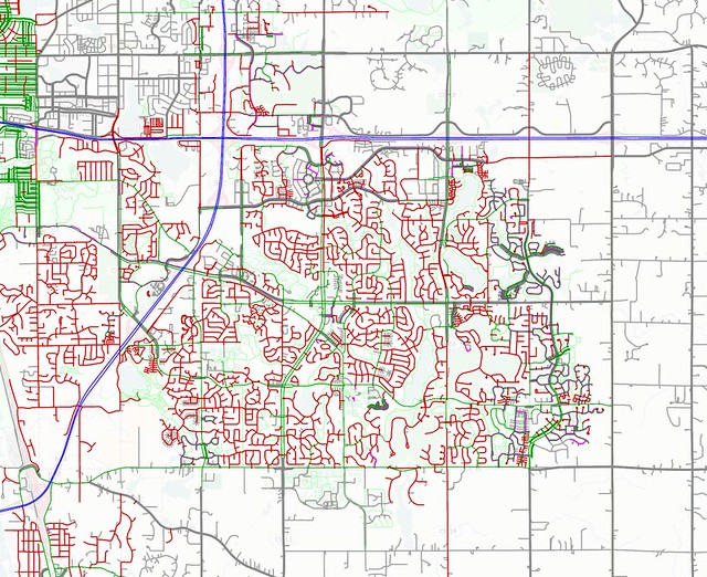
New bus services through Woodbury would need to have their routes checked for adequate pedestrian infrastructure, and new sidewalks or paths would need to be added where necessary. Woodbury does have a pretty extensive network of off-street paths, however, and it would be important to leverage those routes as much as possible to get people to and from their nearest stops.
The Gold Line really only skims the surface of what's needed for proper transit service in the East Metro, and current plans undervalue the need for infill development in existing built-up areas. We're heading toward a zero-carbon future, and preparing for that requires us to make the most use of what we already have.
It will be far better to get existing suburbs to build up their missing downtowns and connect into regional public transportation networks than it would be to abandon them in favor of magic new greenfield plans. Our transit plans need to reach the hearts of these communities rather than bypassing them for green pastures.
No comments:
Post a Comment