This time I'm taking a look at North Dakota, one of our neighbors to the west and a state which also lies along the route of the Empire Builder, Amtrak's only service through our two states. Despite having only about 1/7th the population of Minnesota, North Dakota still has a huge 3,480-mile rail network as of 2014. That's 78% the size of Minnesota's system (4,444 miles), 97% as big as Wisconsin's (3,600 miles), and 137% the size of Norway's rail network (2,540 miles). That's really remarkable for a place with only about 757,000 people.

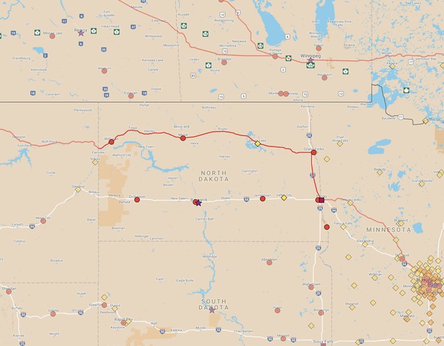
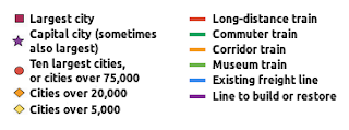
Map of existing passenger train service in North Dakota and nearby areas.
The map above shows the route the Empire Builder takes as it crosses through the region, with markers showing cities of 5,000 people and up. Only 12 cities in North Dakota are that large:
| City | Population (2015 est.) | Note |
|---|---|---|
| Fargo | 115,863 | Served by Amtrak |
| Bismarck | 68,896 | |
| Grand Forks | 56,057 | Served by Amtrak |
| Minot | 47,997 | Served by Amtrak |
| West Fargo | 31,771 | Fargo metro area |
| Williston | 24,562 | Served by Amtrak |
| Dickinson | 22,322 | |
| Mandan | 20,820 | |
| Jamestown | 15,446 | |
| Wahpeton | 7,903 | |
| Devils Lake | 7,288 | Served by Amtrak |
| Valley City | 6,676 |
Amtrak serves five of those cities (Fargo, Grand Forks, Devils Lake, Minot, and Williston) plus two other smaller towns (Rugby, pop. 2,846, and Stanley, pop. 2,721).
The sparse nature of North Dakota is one reason why I used the 5,000-person population as a threshold for making my maps for this series of articles—you need to go that low to get more than ten cities of sufficient size in this part of the country. Remarkably, the twelve cities in that table account for 56% of the people in North Dakota (you only need to go down to number 8, Mandan, to exceed 50%), showing that even heavily rural states still concentrate people into a small number of places.
Incidentally, the encampments of people who have been demonstrating against the Dakota Access Pipeline could add up to another "city" meeting the threshold for my maps. Tribal leaders said that the camps had seen more than 10,000 people, though they're likely shrinking now following the announcement on December 4th that an easement had been denied for the pipeline's final segment. The camps are located along the Cannonball River near where it meets the Missouri River (about halfway between Bismarck and the border with South Dakota).
 |
| Map of North Dakota's rail system, from the 2007 state rail plan. |
Northern Pacific operated a few passenger trains on their mainline, one of which was the North Coast Limited, one of the many routes that was discontinued in 1971 when Amtrak took over nearly all intercity train service in the country. However, an "experimental" train service that Amtrak called the North Coast Hiawatha was brought back on the same route later that same year. Unfortunately, it was only a half-hearted attempt, since the train only ran three times weekly per direction for most of its existence (aside for a few peak summertime travel seasons when it operated daily). The line was finally dropped in 1979 after a round of federal budget cuts for Amtrak.
That's likely the best corridor to add back as a passenger line in the state, since it connects several larger communities. Amtrak studied restoring the North Coast Hiawatha back in 2009, something that was mandated under the previous year's American Recovery and Reinvestment Act (ARRA). Of course, no funding for implementation ever followed, so the report is now gathering dust. Nonetheless, it gives some guidance as to what the challenges would be for bringing back service along that corridor.
Restoring passenger trains on the line would reconnect Fargo to Valley City, Jamestown, Bismarck, Mandan, and Dickinson, and it would be worth considering having it head south from Fargo to reach Breckenridge/Wahpeton to completely reconnect the state's larger towns.
However, it would be best to go beyond simply adding that second route through the state. Today's Empire Builder only serves Fargo and Grand Forks in the extreme early morning hours, and Amtrak's North Coast Hiawatha study also planned to stop in most North Dakota destinations between midnight and 7 a.m., which is not a pleasant time to be arriving or departing. Proper service during daylight hours would be much better for the state.
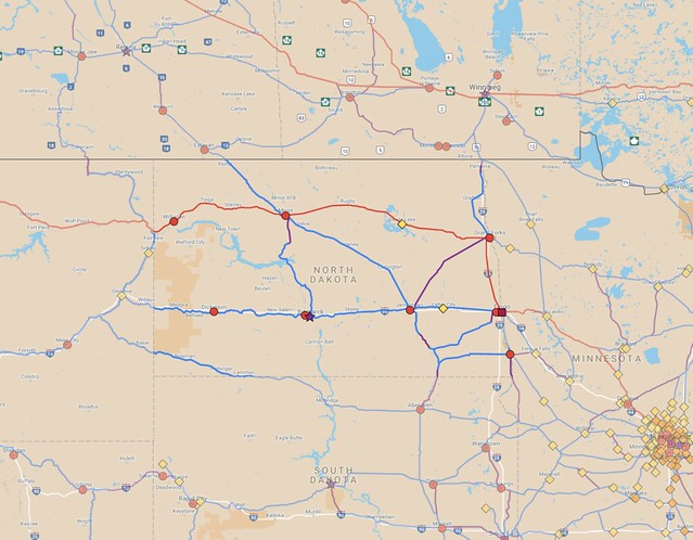
I think it would be best to add a few more routes to build up a mesh of lines. Below is a map of routes in North Dakota and nearby areas that I think would likely have the greatest chance of success, if proper investments were made and trains ran a few times a day, and not just at night or early in the morning:

A map of suggested improvements in North Dakota. Zoomable version.
If there were only the two east-west routes, people wishing to travel from Bismarck to Minot (for instance) would have to circle all the way through Fargo and Grand Forks, or possibly go west to somewhere in Montana in order to make a transfer. However, there are some decent options for shortcuts that could be considered.
On this map, I included a route from Jamestown to Minot which would help with that situation. Transferring in Jamestown would shorten a Bismarck–Minot trip by about 210 miles. There's also a rail line heading almost straight north from Bismarck and nearly reaching Minot, but it falls about 27 miles short. Filling in that gap would shorten a Bismarck–Minot trip by over 340 miles.
I also tried to make a few reasonable guesses as to what might work for cross-border lines into South Dakota and Canada. Much of South Dakota's population is in the eastern 1/3rd of the state, so it makes the most sense to try and run lines south from Fargo, Wahpeton, and Jamestown. However, significant pieces of the lines that formerly ran north and south have been abandoned, so they would be more costly to bring back.
A former transcontinental route built by the Milwaukee Road cuts through the southwestern corner of North Dakota. That's a fairly low-population route, and would probably be a low priority, but it would help connectivity through Aberdeen, South Dakota, that state's third-largest city.
Fargo and Grand Forks line up well for facilitating a corridor toward Winnipeg in Manitoba. Unfortunately, a short stretch of track that used to run straight into Canada near Pembina, ND has been abandoned. I included a suggestion in the map to build a short new connection via the existing border crossing between Noyes, Minnesota and Emerson, Manitoba. Reaching Winnipeg would allow a connection to Canada's passenger rail system, such as it is. Two services currently operate to and through Winnipeg: Via Rail's Toronto-to-Vancouver Canadian and the Winnipeg-Churchill train, which ends in a small town far north on the shore of Hudson Bay. Those services only operate two or three times per week, however.
Further west, Canadian Pacific has a mainline connection running from Minot northwest into Saskatchewan. The line heads toward Moose Jaw, though building a stretch of connecting track to another parallel line about 30 miles away could redirect trains to the provincial capital of Regina, a significantly larger destination.
Finally, one major disadvantage with the existing freight network in North Dakota is that it's primarily designed for feeding agricultural products east and south toward the Twin Cities and Chicago. There aren't many lines that that cut against that grain. I included a suggestion for a line running northeast from Jamestown, which could shorten journeys for people traveling from Bismarck to Grand Forks, for instance, without forcing a transfer in Fargo. However, a route like that would probably be among the lowest priorities for anyone wishing to rebuild a passenger system in the state.
The Empire Builder runs a little over 420 miles through North Dakota. Adding back the North Coast Hiawatha route would add another 374 miles to the roster of active passenger track in the state. All told, my suggested network would add another 939 miles of service along existing track, plus building or restoring tracks along another 194 miles. Along with the existing Empire Builder, that adds up to 1,554 miles. If it were all built, that mean that about 42% of the state's rail network would be supporting passenger service, compared to just 12% today.
Clearly, the biggest bang for the buck would come from restoring service straight west from Fargo along the old Northern Pacific corridor. Amtrak's study from 2009 looked at the whole 2,200-mile route and estimated it would cost a bit over $1 billion to restore once-daily train service over that whole distance (including about $330 million for new train equipment to run over the tracks). That's a heartburn-inducing figure, but things become very costly when talking about such huge distances.
The Dakota Access Pipeline provides an interesting point of comparison, since it is estimated to cost about $3.7 billion over a 1,172-mile route. It is a very different thing from a railroad, but it makes me wonder what we could achieve if similar amounts of money were put into passenger service or improvements for existing freight trains. For instance, $3.7 billion would probably pay for converting 1,500 to 2,000 miles of railroad to electrified service, allowing a substantial number of diesel locomotives to be retired and replaced with more efficient, emission-free units instead.
Hopefully we can turn a corner soon and focus more on moving people rather than petroleum. It's something of a long shot in today's political climate, but something worth thinking about. North Dakota's rail network also seems oversized for a place with its population, so it is a good idea to think about which routes are most important for preservation going forward. There have been many missteps in recent decades where good routes have been prematurely abandoned, so it would be wise to learn from those mistakes and try to make better decisions for the future.

No comments:
Post a Comment