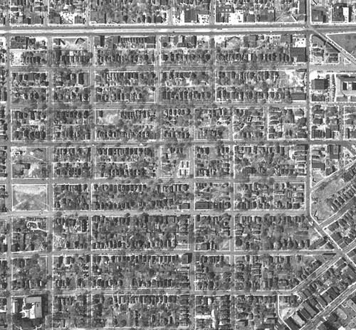
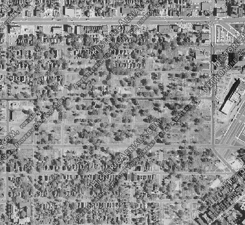
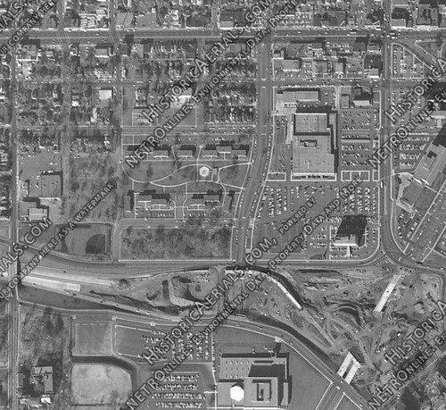
Anyone who has followed the Central Corridor light-rail project has heard of Saint Paul's old Rondo neighborhood and how that community was displaced in the 1950s. The story goes that businesses and homes were torn down in the corridor between St. Anthony Avenue and Rondo Avenue (now mostly known as Concordia Avenue) in order to make way for the Interstate. The spectre of Rondo has weighed heavily on planners and transit advocates who don't want to see past mistakes repeated along the Central Corridor line. However, it's clear that many people involved have been unaware of the truly massive scale of what happened in the 1950s and 1960s. For example, did you know that all of this land had been leveled in the 1950s?
View Urban renewal in the I-94 corridor in a larger map
Many buildings outside of that zone were also taken down, but typically in a more fine-grained manner, one or two at a time. But Rondo got painted with a broad brush and saw block upon block torn down.
Take a look at these aerial photos from 1947, 1957, and 1966. A large swath of destruction north and south of the highway trench is clearly visible.
Most of the homes and businesses that got demolished were not directly in the path of the highway, so it's a bit disingenuous to blame the neighborhood's destruction on I-94. It does seem to be true that the forces behind urban renewal and those behind the Interstate Highway System colluded to clear city slums in that era—indeed, some historians point to Franklin Roosevelt as an early advocate for demolishing run-down city centers and replacing them with gleaming new highways.
With an area that's gone through upheavals and near-total annihilation, I understand why residents with memories of Rondo have been concerned concerned about the impact of Central Corridor light-rail construction on the area. At the same time, however, the CCLRT is not going to decimate the landscape like highways did.
On its face, it is worrying to hear that 130 to 140 parcels are being acquired either through purchase or eminent domain along the light-rail line's route, but nearly all of those just represent slivers of empty land a few feet wide, where the University Avenue right-of-way had to be expanded outward in order to fit two LRT tracks, four traffic lanes, and the occasional turn lane. Other parcels are parking lots that will only be temporarily condemned so that work equipment can be stored near the street, and a few spaces are being used for permanent electrical substations to power the trains. Officially, the only building to face demolition for being in the path of the LRT line was the old Bremer Bank building in downtown (which I frankly found to be ugly anyway).
There are many other structures that have been torn down in the last few years along University Avenue, but that has been anticipatory development where new, relatively dense condos and apartment buildings replaced older structures—the opposite of what was going on in the 1950s when block upon block was torn down and replaced by tower-in-the-park structures or other clustered development where the resulting density appeared to be high, but on average turned out to be much less than what used to be there. Other suburban-style developments also crept in, such as at Sears where more land is devoted to parking than to the two-story building itself. While there have been concerns about neighborhood residents about "Manhattanizing" the area with skyscrapers, the historic destruction of the neighborhood has left many open spaces that can be filled with new homes and businesses without having to tear anything down or build anything especially tall. The Sears space alone could easily accommodate hundreds of new housing units if demand arises.
Bizarrely, even though I think Central Corridor planners have learned many lessons from what happened in the past, they still plan to run light-rail tracks immediately in front of the two surviving buildings I mentioned at the top of this post. On that block, the tracks will shift from running down the middle of University Avenue to running along the south side of the street, blocking driveways for those businesses. This will certainly frustrate the business owners, but the block they are on still has ample parking accessible from other nearby streets. I can't say that the owners will be happy with their new situation, but they won't be completely blocked off—actually, they'll be among the structures closest to the Rice Street/Capitol station, and should benefit from that.
(Incidentally, the next building to the west on that block is Saint Paul's current Greyhound depot. It will also be blocked from the street, but it doesn't matter too much since Greyhound is expected to move to the Saint Paul Union Depot by the end of 2012.)
So, while the story of I-94 and the urban renewal that went with was one of mass destruction, the story of the Central Corridor is merely one of major disruption. It will make a mess of the street for a while, and there's no guarantee that businesses will make it all the way through the construction phase—but those buildings will remain standing and will be ready to be re-occupied by newcomers at any time. In the end, I still strongly believe that the project will have been worthwhile, and hopefully it will bring about much more investment in the corridor that will make it busier and more vibrant.
It would be fascinating to see how many houses were removed, how many trees were removed, how many square blocks were leveled, how many people were displaced, etc. Not recommending that you or I do the counting, however! Yet it would provide quite the contrast for those who are comparing the destruction of Rondo to any transit project.
ReplyDelete