
A map of the city blocks of Saint Paul. Click here for full map.
In my previous post, I compared the city block layouts of the downtowns of Minneapolis and Saint Paul. This time, I thought I'd zoom out and compare the whole cities. Above is the map for Saint Paul, a city of about 300,000 residents. Blocks that are green, yellow, and dark red are smaller in size, less than 15 acres, while pink blocks are larger. That's a fairly arbitrary size to mark a transition between small and large blocks, but generally fits with where I'm comfortable getting around. A 15-acre block is at least 0.6 miles in circumference, taking about 12 minutes to circle on foot, with the time and distance increasing as blocks get longer, thinner, and begin to take on strange shapes.
In general, the map shows blocks of the tightest loop you can make with surface streets to circle around any particular point in the city. Some of these blocks extend well beyond the city borders, so these maps make the cities look a bit larger geographically than what you normally see. To simplify my mapmaking, I generally required streets to have car and bike and pedestrian access, which excluded freeways (illegal to walk or bike on) and made campuses and parks look less permeable here than they would be to someone using non-motorized transportation.
The color coding helps indicate the presence of one-way streets and how they impact navigation by car (usually with the same rules applying for bikes). Green blocks can be circled clockwise, while yellow and dark red blocks have one-way streets on their edges that either require at least one left turn (circling the block counter-clockwise), or have turn conflicts that prevent looping the block.
As I noted in my last post, downtown Saint Paul is relatively isolated from the rest of the city, but a dense street grid reaches through most other neighborhoods, creating large, fairly contiguous regions that are fairly easy to walk and bike around, and that can sop up large volumes of car traffic.
Individual neighborhood "islands" contain scattered large block within them, and are separated from each other by longer corridors. The city's network of highways and railways also fans out from the downtown area through the rest of the city. These tend to run past industrial and low-density commercial blocks, but also sometimes bump into other areas of limited development.
Many large blocks appear because of natural impediments like rivers, lakes, and steeply sloping hills. The Mississippi River valley marks the most significant area of big blocks through the city, with wide river flats areas that are largely un- or under-developed. The West Side Flats area just across the river from downtown is notable for getting its residential population cleared out in the 1960s after flooding devastated the area the decade before. However, the low-density commercial development that replaced it still contributes to downtown's isolation from the rest of the city.
Some large blocks on the map are fairly private spaces like cemeteries and golf courses, while others are more permeable to foot and bicycle traffic, such as parks and school campuses.
The relatively sparse road network on the western edge of Saint Paul creates a large lobe extending well into Minneapolis along BNSF rail corridors.
I mapped out 3508 small blocks and 248 large blocks in Saint Paul, which is a ratio of about 14:1. Let's take a look at Minneapolis and see how it compares:
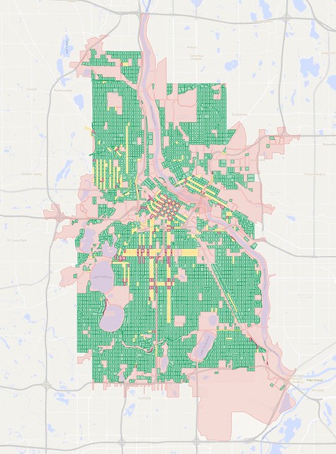
A map of city blocks in Minneapolis. Click here for full map.
Minneapolis is somewhat larger and denser than Saint Paul, with a population of about 407,000. Regions of small blocks are even more contiguous than in Saint Paul, perhaps aided by the fact that the city is a bit flatter than its neighbor to the east.
Interestingly, the Mississippi River channel is narrower through Minneapolis (the city sits upstream of the confluence with the Minnesota River). It's also a bit harder to see freeways cutting through the city than I would have expected.
One-way streets extend much farther into Minneapolis's neighborhoods than into Saint Paul. Some of these one-ways essentially make highways through town, while others are in place because of narrow streets or heavy volumes of parked cars in denser neighborhoods.
Railroads still cut through parts of the city, particularly in paths radiating to the west of downtown and in through Northeast and Southeast Minneapolis, but they don't have quite the same impact as in Saint Paul. The areas northeast of the Mississippi also host a large amount of industrial land along Interstate 35W and the rail corridors. Surface streets are so limited in that area that the convergence of I-35W, Minnesota State Highway 280 and MN-36 creates a "block" that extends all the way to Fairview Avenue—kitty-corner to Rosedale Center mall.
Similarly, the sparse road network along the I-394 corridor creates blocks that extend well into St. Louis Park and Golden Valley, even reaching past MN-100. That same highway makes a significant barrier on the northeastern edge of the city, so circling on surface streets would take you through parts of the old Brookdale Mall in Brooklyn Center.
Circling the block along the MN-62 corridor on the south end of Minneapolis will take you into Richfield, and a large lobe also extends south of the city to encircle Minneapolis–Saint Paul International Airport, which takes up most of the unincorporated area of Fort Snelling.
When making this map, I was surprised at how many blocks were crammed close to Lake Harriet, Lake Calhoun, and Lake of the Isles. Even areas around Lake Nokomis and Diamond Lake have had a lot of stuff built quite close to them.
Planners in Minneapolis have used the street grid and other small-block layouts to great effect since the city was founded, filling almost every nook and cranny they could find. I count 4,701 small blocks on this map, plus another 225 big blocks—a ratio of nearly 21:1 (significantly higher than Saint Paul's 14:1).
How do you think the suburbs fare in comparison? Stay tuned for a future post.
No comments:
Post a Comment